Weather temperatures on roller coaster for next few days, severe weather possible Saturday
Published 9:46 am Friday, January 18, 2019
NATCHEZ — The roller coaster weather pattern will continue at least for another week, according to the National Weather Service forecasters in Jackson.
Meteorologist Daniel Lamb said the area should expect temperatures to be up and down “real quickly” as two cold fronts move through the area this weekend and early next week.
Lamb said Saturday morning the state should expect a strong weather system to push through.
“We are expecting a strong cold front to come through during the daytime, likely at daybreak (for the western part of the state),” Lamb said.
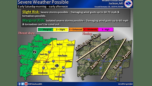
The storms will bring a slight risk of severe weather, including damaging wind gusts up to 60 mph and possible tornadoes.
The western side of the state will see storms pass through the area from 2 a.m. to 10 a.m. Areas east of I-55 will see the strong cold front push through between 8 a.m. and 2 p.m. For northern parts of the state, the cold front will bring chances of a wintry mix of sleet and snow Saturday evening.
The cold front should move quickly and the temperature will begin to drop throughout the day Saturday in Sunday morning.
For Oxford, temperatures should drop to 26 degrees Sunday morning and warm up into the upper 30s Sunday. In Natchez, lows Saturday night into Sunday morning should drop to near freezing, then gradually warm up to 44 degrees Sunday.
Clearing skies Sunday night should bring even colder temperatures, Lamb said, with lows forecast to drop to the low 20s in the northern part of the state and the high 20s in the southern part of the state.
“It will be cold but fortunately warming up pretty quickly,” Lamb said.
In Natchez, the temperature will quickly warm up to 54 degrees Monday and 62 degrees Tuesday. In Oxford, the temperature will also rise into the 50s Tuesday.
Another cold front will move through the area Tuesday evening dropping temperatures once again for the state. In most of the state, highs on Wednesday should be in the low 40s with lows near or just below freezing.