All eyes on Gulf as formation of Hurricane Barry expected by Friday
Published 2:26 pm Wednesday, July 10, 2019
The National Hurricane Center says an area of low pressure in the northeastern Gulf of Mexico is producing disorganized showers and thunderstorms, but the disturbance is expected to grow into a tropical depression tomorrow and strengthen to a hurricane by Friday.
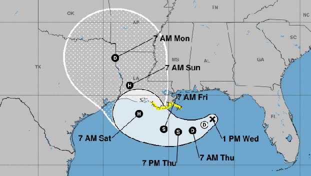
At 1 p.m. the disturbance was centered near latitude 28.3 North, longitude 86.7 West. The system is moving toward the west-southwest near 8 mph. A motion toward the west-southwest or southwest is expected through Thursday morning, followed by a turn toward the west late Thursday and a turn toward the west-northwest on Friday.
By early Saturday, a northwest motion is expected. On the forecast track, the system is expected to approach the central U.S. Gulf Coast this weekend.
Maximum sustained winds are near 30 mph with higher gusts. Strengthening is forecast during the next 72 hours, and the disturbance is forecast to become a tropical depression Thursday morning, a tropical storm Thursday night and a hurricane on Friday. The storm would be named Barry.
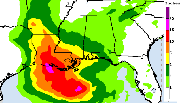
The system is expected to produce total rain accumulations of 6 to 12 inches near and inland of the central Gulf Coast through early next week, with isolated maximum rainfall amounts of 18 inches.
Rainfall amounts exceeding 6 to 9 inches have already occurred across portions of the New Orleans metropolitan area today, which has resulted in flooding.
The heavy additional rain could push the already swollen Mississippi River precariously close to the tops of levees that protect New Orleans, officials said.
Louisiana Gov. John Bel Edwards warned that there could be “a considerable amount of overtopping” of levees in Plaquemines Parish, which is southeast of New Orleans and includes many of the city’s suburbs.
But the risks extended beyond New Orleans, the governor said. National Guard troops and high-water vehicles will be positioned all over the state, he said.
“The entire coast of Louisiana is at play in this storm, and we’re talking about as much as 10 to 15 inches (25 to 38 centimeters) of rain over a 24-hour period that will start Friday. So that is a short time period for such intense rain,” Bel Edwards said.
The governor planned to declare a statewide emergency later Wednesday.
In New Orleans, garbage containers were tilted on their sides and pieces of wood floated down flooded streets. Water was up to the doors of many cars during the morning rush hour.
Meanwhile, the low pressure area was over water, south of the Florida Panhandle. It was expected to grow into a powerful storm as it moved west through the Gulf’s warm waters.
Lines of thunderstorms associated with the system ranged far out in into the Gulf and battered New Orleans, where as much as 7 inches (18 centimeters) of rain fell over a three-hour period Wednesday morning, forecasters said.
In the days ahead, parts of Louisiana could see up to 12 inches (30 centimeters) of rain by Monday. As much as 18 inches (46 centimeters) of rain could fall in isolated areas, forecasters said.
Mississippi and Texas were also at risk of torrential rains.
New Orleans is protected to a river level of 20 feet (6.1 meters), but it was forecast to rise above flood stage to 19 feet (5.8 meters) by Friday, the National Weather Service said.
The Associated Press contributed to this report.


