Expected tropical depression could dump significant rainfall, storm surge could worsen flooding
Published 6:40 am Wednesday, July 10, 2019
A tropical depression is expected to form over the northern Gulf of Mexico later today or Thursday as a trough of low pressure moves south off the U.S. mainland and over the warm Gulf waters.
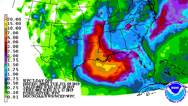
The storm, now named Invest 92L may dump significant rainfall over parts of Mississippi and Louisiana that are still dealing flood that’s been going on for six months.
National Weather Service forecasters say it’s difficult to predict the path of a storm that has not yet formed, but models show rainfall totals over the next seven days could range from 3 to 7 inches or more over portions of Mississippi and Louisiana.
Forecasters say all residents along the Gulf Coast need to stay alert as the storm develops.
River watchers along the lower Mississippi River are concerned by the storm for two reasons.
First, the storm could dump lots of rain, very quickly in an already overworked flood control system.
Second, depending upon the storm’s strength and where it makes landfall, the storm surge could potentially force Gulf water to rise, then pushing back up the Mississippi River’s already flooded levels. NOLA.com reported late Tuesday that forecasters believe a storm-surge heightened river should still be below the tops of the levees that surround the Crescent City.
But all of that could change depending upon how much Invest 92L strengthens and where it lands. Please stay tuned to the weather over the next several day until this storm passes.