Storm-to-be-named Barry strengthens overnight, latest track aims straight for flooded Mississippi valley
Published 7:13 am Thursday, July 11, 2019
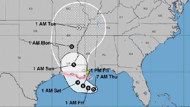
Although an anticipated tropical storm has yet to fully develop over the Gulf of Mexico, weather forecasters say that will happen later today and its expected track has shifted in the latest update turning more to the north.
The shift puts the path almost directly along the lower Mississippi River Valley, where the storm, which will be named Barry, is expected to dump massive amounts of rain over the already flooded region.
Forecasters still believe the low pressure system will develop quickly over the next few days eventually making landfall in south Louisiana, likely as a hurricane.
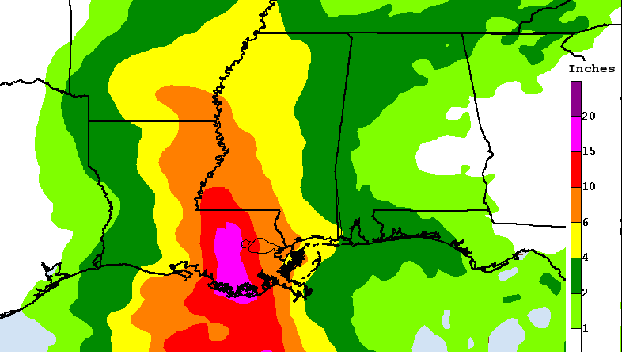
The storm has the potential to dump significant rainfall over areas of Mississippi.
Meteorologist Greg Garrett from the National Weather Service in Jackson said the system is still at a point where it is too difficult to predict the exact path of the storm.
Current models show the storm has the potential to dump up to 10 inches of rain over portions of Mississippi as it moves inland. Those models are very preliminary, Garrett said.
“Our models right now are all over the place,” Garrett said. “There is still a lot of uncertainty as to where it will make landfall and how much rainfall there will be.”
Garrett said the storm, which was classified as a Tropical Cyclone Two on Wednesday afternoon, is expected to strengthen into a tropical depression, with the potential to become a hurricane before it makes landfall.
“Right now it is sitting over the north central Gulf and is not a tropical depression yet,” Garrett said Wednesday afternoon.
At 7 a.m. Thursday the disturbance was centered near latitude 27.6 North, longitude 88.5 West. The system is moving toward the west near 5 mph , but a west-northwest motion is expected on Friday followed by a northwestward track by early Saturday. On the forecast track, the system is expected to approach the Louisiana coast this weekend.
Maximum sustained winds are near 35 mph with higher gusts. Strengthening is forecast during the next 72 hours, and the disturbance is forecast to become a tropical depression today, a tropical storm tonight and a hurricane on Friday.
Garrett said portions of south Mississippi could start seeing effects from the tropical system on Friday night when the outer rain bands from the storm move into the area.
“The outer rain bands have the potential to be prolific rain producers, dumping a significant amount of rain in a short period of time,” Garrett said.
Rainfall amounts exceeding 6 to 9 inches have already occurred across portions of the New Orlean metropolitan area, which resulted in flooding.
Depending on the path of the storm, Garret said rainfall totals could start “mounting up” as areas of rain spread across the region.