Millions in line of Tropical Storm Barry’s likely track, punishing rain
Published 6:56 am Saturday, July 13, 2019
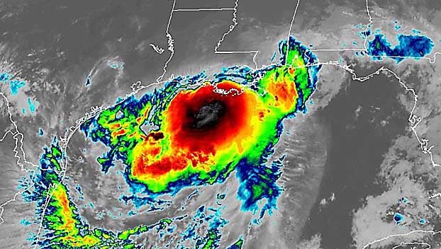
Heavy rains and gusty winds knocked out power on the Gulf Coast as a strengthening Tropical Storm Barry churned a path to shore, threatening millions and testing flood-prevention efforts implemented after Hurricane Katrina devastated New Orleans 14 years ago.
Officials predicted Barry would make landfall as this year’s first hurricane Saturday morning near Morgan City, west of New Orleans, where a curfew has been set until 6 a.m. and a long day started with on and off rain, power outages and people using cellphones to see in the dark and opening doors and windows to let the warm, sticky tropical air circulate.
As dawn approached Saturday, more than 45,000 people in southern Louisiana had lost power. The edges of the storm lashed Louisiana and coastal Mississippi and Alabama with rain, leaving some roads underwater overnight.
Though expected to be a weak hurricane — just barely over the 74 mph (119 kph) wind speed threshold — it threatened disastrous flooding across a swath of the Gulf Coast. The storm was expected to inflict the most damage on Louisiana and parts of Mississippi, with wind and rain affecting more than 3 million people.
Late Friday night, residents received good news from forecasters: The Mississippi River is expected to crest in New Orleans at about 17.1 feet (5.2 meters) on Monday, not 19 feet (5.8 meters) as had been earlier predicted. The levees protecting the city range from about 20 to 25 feet (6 to 7.5 meters) in height.
On-again, off again tropical showers hit New Orleans overnight. As day broke, the streets in the famous French Quarter tourist district were barely damp. It was breezy, but flags on balconies overhanging the empty streets still occasionally fell limp. A few cars were out on roads.
But forecasters warned most of the storm’s rain remained over the Gulf of Mexico and would likely move into Louisiana and Mississippi later Saturday. There were predictions of 10 to 20 inches (25 to 50 centimeters) of rain through Sunday across a swath of Louisiana that includes New Orleans and Baton Rouge with some parts of the state possible getting 25 inches (63 centimeters).
“It’s powerful. It’s strengthening. And water is going to be a big issue,” National Hurricane Center Director Ken Graham warned.
Governors declared emergencies in Louisiana and Mississippi, and authorities took unprecedented precautions in closing floodgates and raising the barriers around New Orleans.
Gov. John Bel Edwards said it was the first time all floodgates were sealed in the New Orleans-area Hurricane Risk Reduction System since Katrina. Still, he said he didn’t expect the Mississippi River to spill over the levees despite water levels already running high from spring rains and melting snow upstream.