Tropical moisture surges across Mississippi Friday and through weekend, flooding downpours likely
Published 10:52 am Thursday, August 22, 2019
By Alex Sosnowski, AccuWeather senior meteorologist
A new surge of tropical moisture will lead to a proliferation of downpours and the risk of flooding along the Gulf coast as well as the interior South this weekend
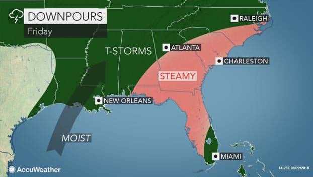
Following slow-moving downpours along the upper Gulf coast this week, a new surge of tropical moisture will lead to a proliferation of downpours and the risk of flooding along the Gulf coast as well as the interior South this weekend.
Portions of the upper Gulf coast have received upward of 6 inches of rain this week. Panama City, Florida, picked up nearly 8 inches of rain in three days with 6.59 inches falling on Boothville, Louisiana, during the same time frame.
Downpours will continue from the upper Texas coast to northern Florida through this week.
Meanwhile, an area of tropical downpours moved from Mexico’s Yucatan Peninsula on Wednesday to the western and central Gulf of Mexico on Thursday..
Boating and beach interests should be prepared for quickly changing weather and wave conditions into this weekend.
Significant tropical development of this feature is not anticipated.
However, there does not have to be a tropical depression or storm for heavy rainfall and flooding to occur.
Along the Louisiana coast and the uppermost part of the Texas coast, there is the potential for a general 4-8 inches of rain through this weekend with locally higher amounts. This rain is on top of what has fallen through Wednesday.
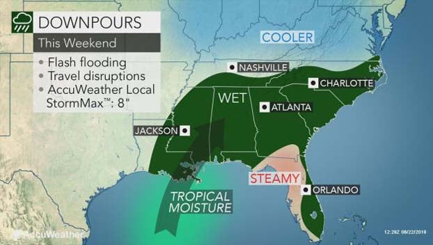
This batch of drenching showers and thunderstorms is then forecast to take a northeastward path from Louisiana and Mississippi, to portions of Alabama, Tennessee, Georgia and the Carolinas this weekend.
“It looks like the tropical moisture will run into a cool front that we expect to sag southward this weekend over the interior South and squeeze out a great deal of rain,” according to AccuWeather Senior Meteorologist Frank Strait.
Another bull’s eye of heavy rain is likely to be centered over the southern Appalachians, where another 4 inches of rain or more may fall as this front interacts with the moisture.
Not only may the downpours foul weekend outdoor plans as the last unofficial days of summer wind down, the rain may be heavy enough to cause significant flash flooding in some communities and force some secondary roads or city streets to close for a time.
As if this were not enough, part of this same plume of tropical moisture may become involved with another area of showers and thunderstorms of tropical origin next week.
This tropical disturbance traveling northwestward across the Bahamas is forecast to spread drenching downpours into part of the Florida Peninsula this weekend.
The moisture and tropical disturbances involved over the Southeastern states and the Bahamas may eventually give rise to an organized tropical system next week somewhere just off the Atlantic coast.