Dorian gets stronger, expected to be major hurricane soon; chance it could cross into Gulf after striking Florida
Published 11:29 am Wednesday, August 28, 2019
By Courtney Spamer, AccuWeather meteorologist
Tropical Storm Dorian made a shift to the north on Wednesday causing its center to regenerate northeast of Puerto Rico and putting forecasters on alert for development of the Atlantic’s first major hurricane of the 2019 season.
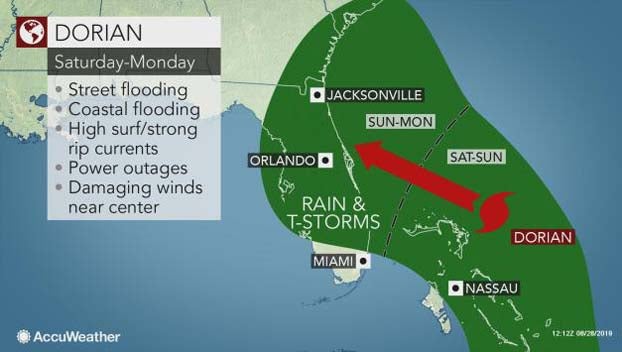
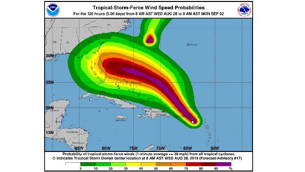
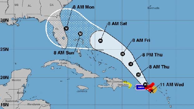
Dorian was verging on hurricane strength on Wednesday, packing 70 mph winds as it moved northwest at 13 mph about 25 miles south of St. Croix. As it tracks north of the Bahamas later this week, Dorian is expected to reach Category 3 strength before approaching the southeastern U.S. coast.
The storm continued to bring waves of heavy rain to Puerto Rico and parts of the U.S. and British Virgin Islands on Wednesday after it battered portions of the Lesser Antilles on Tuesday.
Moving into the warm waters of the southern Atlantic will provide the right conditions for Dorian to strengthen; AccuWeather meteorologists are forecasting Dorian to intensify into a major hurricane before making landfall as a Category 2 hurricane. Water temperatures in the Atlantic range from from 84 degrees to 86 degrees along the projected path Dorian is expected to take.
“Dorian shifted to the north, and as it travels over warm open waters, will undergo rapid strengthening; the system is likely to become a hurricane before the end of the day,” said AccuWeather Hurricane Expert Dan Kottlowski.
The longer the tropical system stalls over the waters of the Atlantic, the better chance Dorian has of strengthening to a major hurricane.
Interests north and east of the Bahamas should prepare for conditions of a hurricane. Some of the far northern islands of the Bahamas will get significantly impacted while the majority of the others with barely a breeze and a little rain.
A swath of heavy rain, locally damaging winds and battering surf is in store, but the worst conditions are likely to be over a relatively narrow path over open water and across the northern islands of the Bahamas like Grand Bahama and Grand Abaco.
At this time, lesser impacts are expected across the southern half of the Bahamas, farther away from the track of Dorian.
With several days over the open waters of the Atlantic still to go, the exact track of Dorian for the weekend and beyond is not set in stone.
“A very small fluctuation in the overall weather pattern will have a large influence in where Dorian ultimately tracks and how it impacts the continental U.S.,” said AccuWeather Senior Meteorologist Adam Douty.