Hurricane Dorian: Breaking storm down by the numbers
Published 4:23 pm Friday, September 6, 2019
By Brian Lada, AccuWeather meteorologist and staff writer
Hurricane Dorian has been an intense storm that will not soon be forgotten. As a Category 5 storm, the highest rating on the Saffir-Simpson hurricane wind scale, it relentlessly pounded the northern Bahamas for two days with devastating winds and catastrophic storm surge decimating the Abaco Islands as well as Grand Bahama.
By the time that Dorian reached the shores of the eastern United States, albeit much weaker than it was at peak strength, it had already left its mark in the history books.
Here are some of the most notable statistics from the deadly hurricane:
High winds and low pressure
At peak intensity, Dorian was a powerful Category 5 hurricane, the fourth year in a row that there was a Category 5 hurricane in the Atlantic basin. This stretch started with Matthew in 2016, Irma and Maria in 2017 and Michael in 2018.
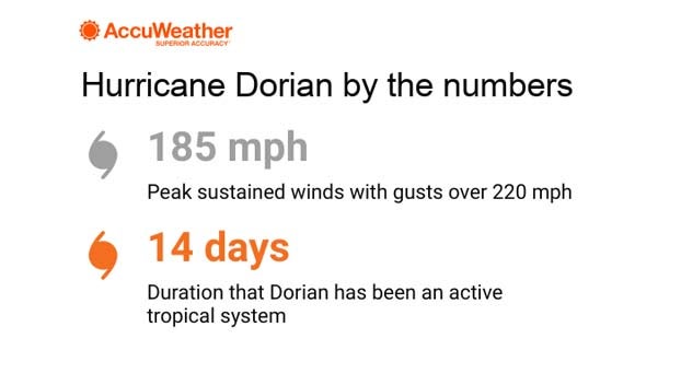
Dorian has been the strongest of the bunch with maximum sustained winds of 185 mph and wind gusts topping 220 mph. To be classified as a Category 5 hurricane, sustained winds must exceed 157 mph.
These incredibly high winds make Dorian tied for the second-strongest hurricane to make landfall on record in the Atlantic basin, falling just shy of Hurricane Allen, which packed winds of 190 mph back in 1980. It is also the strongest hurricane to ever make landfall in the Bahamas.
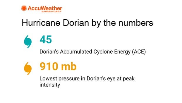
Not only did Dorian pack powerful winds, but its central pressure dropped to remarkably low levels.
When it was at peak strength, Dorian’s central pressure was 26.87 inches of Mercury (910 millibars). This is tied for the ninth-lowest pressure measured in the eye of a hurricane since 1980.
Triple landfall in the Bahamas
Shortly after reaching peak strength, Dorian made a catastrophic landfall in the northern Bahamas.
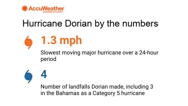
The unprecedented hurricane first made landfall on Elbow Cay, Abacos, around 12:30 p.m. EDT on Sunday, Sept. 1, 2019. By 2 p.m. EDT, Dorian made a second landfall on Great Abaco Island near Marsh Harbour. By 11 p.m., the eye of the storm had made landfall over the eastern end of Grand Bahama Island.
After hammering the Bahamas, Dorian tracked up the coast of the eastern U.S., making a fourth landfall Cape Hatteras, North Carolina, at 8:35 a.m. EDT Friday, Sept. 6, 2019.
Dorian stalls and spins over the Bahamas
As Dorian tracked over Grand Bahama Island, its forward momentum came to a halt, causing the storm to stall over the island. This was devastating to the northern Bahamas, putting some areas in the wrath of the Category 5 hurricane for more than a day.
Over the span of 24 hours, Dorian’s average speed was just 1.3 mph, the slowest speed for any major hurricane since records began in 1851, according to Robert Rohde, a lead scientist at Berkeley Earth. For a time during this 24-hour window, the storm was completely stationary.
“Most people can easily walk faster than the mere 1.3 mph (2.0 kph) that Dorian has been advancing,” Rohde said on Twitter.
The elongated life of Dorian
The slow motion that Dorian has exhibited has helped to make this hurricane live longer than many others.
“Dorian’s longevity as a hurricane is not particularly noteworthy. Its longevity is slightly more impressive as a named storm,” Colorado State University meteorologist Phil Klotzbach told AccuWeather in an email. Klotzbach is a research scientist specializing in Atlantic basin seasonal hurricane forecasts.
This two-week lifespan puts Dorian in the top 10% of all named storms in the satellite era, according to Klotzbach.
Friday marked the 14th day that Dorian was an active tropical cyclone, dating back to Aug. 24, 2019, when it first became a tropical depression.
However, this comes nowhere close to the all-time record for the longest-lived storm in the Atlantic. That record is held by the San Ciriaco Hurricane of 1899 which was classified as a hurricane for four weeks.