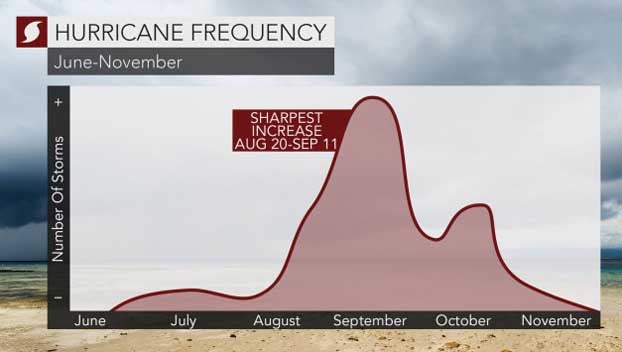
Tropics heating up as hurricane season reaches its traditional peak
Published 2:35 pm Tuesday, September 10, 2019
By Alex Sosnowski, AccuWeather senior meteorologist
With the peak of the Atlantic hurricane season upon us, there are currently a few tropical disturbances that are being monitored over the basin which could approach the Caribbean and North America over the next couple of weeks.
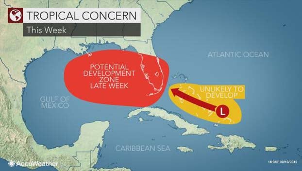
While conditions are relatively quiet over the Atlantic basin at the start of this week, it could be a different story late this week or next week.
During the middle of the tropical season, from late August through the middle of October, most tropical storms are born from tropical disturbances, called tropical waves, that move westward from Africa.
This is also known as the Cabo Verde season, which borrows its name from the Cabo Verde Islands, located just off the west coast of Africa where many of these tropical waves form.
The Cabo Verde season has been responsible for most of the monster hurricanes over the years, including the most recent Category 5 Hurricane Dorian.
However, most of these tropical waves fail to develop due to wind shear, dry air and other inhibiting factors.
There are three tropical waves of note for this week which bear close monitoring.
The first tropical wave remained poorly organized north of Hispaniola early Tuesday morning. As it progresses, forecasters expect it to reach parts of the Bahamas that were just ravaged by Dorian.
“We expect this disturbance to move west-northwest and move across the central and southern Bahamas during Wednesday and Thursday and then across the Florida Peninsula during Friday and Saturday,” AccuWeather Hurricane Expert Dan Kottlowski said.
While this feature is likely to cause an uptick in showers and thunderstorms and inhibit recovery efforts in the northern Bahamas, it may also bring some temporary relief from the heat.
“We feel that there is a chance of development over several days with this disturbance, but that chance is low at this time,” Kottlowski said.
Rapid strengthening of this feature is not anticipated, should low-end development occur.
This means that the Bahamas should not have to deal with a powerful hurricane from this particular disturbance.
Steering winds may allow that disturbance to reach the eastern Gulf of Mexico by this weekend. There is a better chance for organization and strengthening of this feature once it moves past Florida and enters warm waters of the Gulf of Mexico this weekend.
Farther to the east over the Atlantic is another tropical wave, currently dubbed Invest 94L.
“This area of interest, located about 900 miles east of Barbados in the Windward Islands of the Lesser Antilles, will drift westward this week,” Kottlowski said.
“Ninety-four L has also has a low chance of development since it will probably encounter increasing wind shear this week,” Kottlowski added.
However, interests in the Caribbean should monitor the progress of this disturbance.
There is a third tropical wave that is raising a few eyebrows. That feature is a cluster of showers and thunderstorms that pushed off the coast of Africa on Monday.
This feature, like most tropical waves, will drift westward across the Atlantic this week and this weekend.
There is the potential for this feature to develop as it approaches the Lesser Antilles this weekend and crosses the northeastern Caribbean early next week.
A lot may happen with a feature so far out in time due to fluctuation in wind shear and steering winds.
This is a “heads-up” on potential tropical trouble for next week in the Caribbean, Bahamas and coastal areas in the eastern United States.