Tropical threat likely to strengthen over next few days, may emerge in eastern Gulf of Mexico
Published 10:06 pm Wednesday, September 11, 2019
By Maura Kelly, AccuWeather meteorologist
AccuWeather meteorologists are closely monitoring several features for development across the Atlantic, including one disturbance north of Hispaniola that is raising concern.
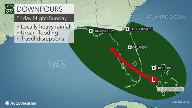
A cluster of showers and thunderstorms associated with a broad area of low pressure is currently located over the southern Bahamas, north of Hispaniola. This feature has been designated as Invest 95L.
Tropical development is not expected over the next couple of days as 95L is located in an environment of high wind shear. However, this feature can still bring locally heavy downpours to the Bahamas.
The heaviest and most widespread thunderstorms will be over the southern Bahamas into Thursday.
By Friday, the threat of heavier downpours will shift to the northern islands as 95L meanders on a generally northwest track.
While storm coverage is expected to be isolated, any downpour can impact recovery efforts in Grand Bahama and the Abaco Islands in the wake of Hurricane Dorian.
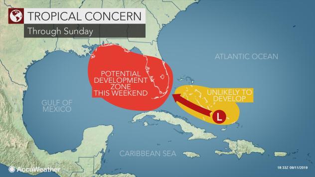
95L looks to then move toward Florida and into an environment more favorable for tropical development. Wind shear will lessen across the eastern Gulf of Mexico, where sea surface temperatures are in the middle to upper 80s Fahrenheit.
“Once that wind shear relaxes, this system is going to strengthen,” stated AccuWeather Chief Broadcast Meteorologist Bernie Rayno.
“Its proximity to the Florida Peninsula as we get into Friday and Saturday should prevent this system from wrapping up quickly,” added Rayno.
The threat of downpours looks to shift farther west through the end of the weekend and into early next week as 95L may track toward the central Gulf Coast.
“Should 95L develop into a tropical depression or tropical storm, a more concentrated area of heavy rain and significant flooding would be possible near the point of landfall along the central or eastern Gulf Coast,” said AccuWeather Senior Meteorologist Adam Douty.
Regardless of tropical development, 95L can bring locally heavy downpours and an increased risk of flash flooding to Florida and the central Gulf Coast this weekend and into the beginning of next week.
Another broad area of low pressure currently located over the central Atlantic can increase shower and thunderstorm activity in the Lesser Antilles into the early part of the weekend.
“The area of disturbed weather designated as Invest 94L is moving west and will reach the Lesser Antilles Friday and Saturday,” stated AccuWeather Hurricane Expert Dan Kottlowski.
The likelihood of tropical development with this feature remains low at this time with strong wind shear over the eastern Caribbean.
Farther east, a tropical wave that moved off the coast of Africa earlier in the week is located near the Cabo Verde Islands.
This feature will pick up speed over the next couple of days as it traverses the Atlantic Ocean toward the Caribbean Sea.
“Don’t expect much from this as we go through this week or even in the weekend,” said Rayno. “However, early next week, as it approaches the islands, this is when we have to watch it.”
High wind shear over the central Atlantic will gradually weaken as the tropical wave continues on its westerly track.
“If a low-level circulation center can become established within this system, it might become an organized tropical system as it moves into the eastern Caribbean early next week,” stated Kottlowski.