Hold on to your long johns, wind chill dropping into teens across state tonight
Published 8:49 am Tuesday, November 12, 2019
A cold day will only turn colder as strong winds and bitter cold settle over much of the state for the next 36 hours, forecasters warn.
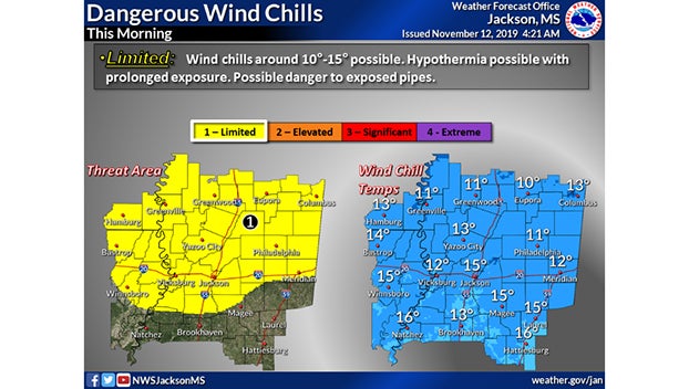
As an arctic blast settles across the Deep South, clearing skies and strong winds will move across most of the state. The National Weather Service has issued a weather alert for the limited threat of dangerous wind chill temperatures north of Interstate 20.
Wind gusts of up to 40mph will be possible throughout the day, A Wind Advisory has been issued through 6 p.m.
Forecasters say wind chill temperatures will be in the teens in areas of the state as far south at Natchez and Hattiesburg. National Weather Service officials recommend taking precautions if you plan on spending significant time outside. Hypothermia is possible with prolonged exposure, forecasters warn.
In the next 24 hours, temperatures will struggle to stay above freezing in the northern part of Mississippi and will drop in the low to mid-20s tonight across the entire state into Wednesday morning. Some isolated areas will dip into the teens.
Much of the state is also under a Freeze Warning this afternoon through 10 a.m. Wednesday as below-freezing temperatures are likely for an extended period of time.