Wet weather, possibly severe storms in forecast for state later this week
Published 11:34 am Monday, January 6, 2020
By Maura Kelly, AccuWeather meteorologist
After a dry start to the week, a midweek storm system can bring heavy rainfall and severe weather potential to the south-central and southeastern United States.
This storm will start the week by bringing coastal rain and mountain snow to the Northwest. By Wednesday and Thursday, the storm will move into the northern Plains where it will have a chance to reorganize after tracking across the Rocky Mountains.
As the storm gathers over the Plains, it will draw moisture from the Gulf of Mexico north into the center of the country. This will also bring warmer air farther north.
Rain is forecast to develop over the central Plains throughout the day on Thursday.
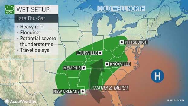
On Thursday night, the storm will be able to tap into the moisture being pulled into the region ahead of the storm and areas of heavy rain can begin to develop from eastern Missouri into western Ohio.
Southerly winds ahead of this feature will continue to pump warm, moist air into the Deep South on Friday, expanding the area heavy rain into the Tennessee Valley and as far east as Georgia.
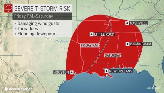
While this storm brings a cold front to the Lower Mississippi Valley, another storm is forecast to develop along this front over the southern Plains and northern Mexico.
Colder, drier air following behind the front will clash with the warm, moist air over the central Gulf Coast, which can cause thunderstorms to develop from eastern Texas into Louisiana and Mississippi.
As the storm system shifts eastward from Friday to Saturday, thunderstorms are forecast to advance over the lower Mississippi Valley while rain continues across much of the Southeast.
With plenty of moisture and energy from the new storm system tracking across the Deep South, there is potential that thunderstorms can become strong to severe.
Flooding rainfall will be the primary threat from thunderstorms rumbling across the region, but the strongest storms may be able to produce strong wind gusts and perhaps an isolated tornado.
While dry conditions will prevail across the southern tier of the United States through the first half of the week, many of these areas received periods of heavier rain to start the year.
Memphis, Tenn., and New Orleans are already approaching half the amount of rainfall the area normally receives throughout the month of January within the first couple of days of the year.
Knoxville, Tenn., which usually receives around 4.32 inches of rainfall in January, has already reported 3.06 inches of rain.
Because of this any rivers across the Lower Mississippi Valley are already running high. Periods of heavy rainfall expected during the end of the week will only exacerbate the risk for flooding across the region.
Farther north, a different type of threat will take shape.
Colder air on the northern side of the storm can yield icy conditions or rain to change over to snow, especially later in the week when the storm moves into New England.
The exact track of the storm will determine how far south snow coverage will be to start the weekend.