Rain to drench South this week, exacerbating already flooded areas
Published 3:07 pm Monday, February 17, 2020
For residents across the southern United States dealing with an abnormally wet weather pattern and flooding, Mother Nature will only bring more of the same this week as a parade of storms keeps the wet weather pattern in place.
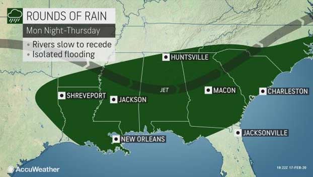
AccuWeather Senior Meteorologist Alex Sosnowski said that, while more storms are expected this week, rainfall is not likely to be as intense as that of recent storms.
“Still, because the ground is saturated in many areas, it won’t take as much rain to trigger small stream and flash flooding,” he said. “Seven-day rainfall on the order of 1-5 inches could also be enough to slow the rate of recession on some rivers and trigger a secondary rise on other rivers.”
The heaviest rainfall may target the Pearl River basin, where the third highest crest on record is forecast at Jackson, Mississippi, from rain that fell prior to this week.
As of Monday morning, there was minor, moderate and major flooding occurring along nearly every gauge on the Mississippi River south of Cape Girardeau, Missouri. Minor to moderate flooding was also common along some larger rivers in the Carolinas, Louisiana, western Alabama and southern Arkansas.
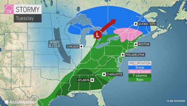
The first round of rain will come on Tuesday and Tuesday night as a frontal boundary extending southward from a storm system bringing snow to parts of the Upper Midwest and Northeast stalls out over the Deep South.
Coverage and intensity of rain will decrease on Wednesday as a brief push of drier air noses into the Deep South.
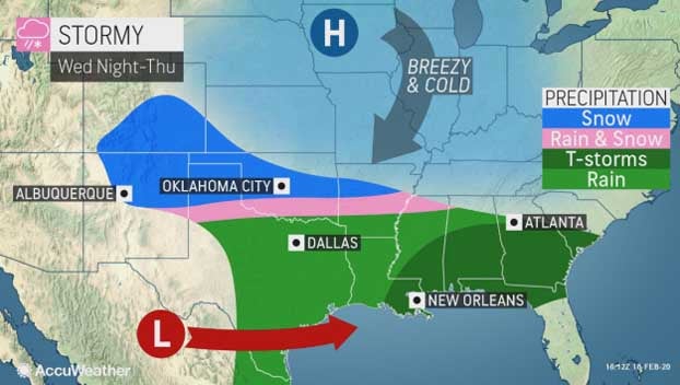
The next round of rain will ramp up across eastern Texas and Louisiana later Wednesday into Wednesday night as another storm system forms along the central Gulf coast near the stalled boundary.
That storm will move northeastward off the South Carolina coastline by Thursday evening, so the heaviest rain in Georgia and the Carolinas from this second system should occur on Thursday before moving offshore late Thursday night.
Although the rain could lead to isolated flooding on smaller streams and creeks this week, it should not fall heavily enough over a large enough area to exacerbate flooding on the Mississippi River or prevent the floodwaters from receding.
Some smaller streams and creeks already near or above flooding stage, however, could crest at even higher levels than they have over the weekend.
In addition, motorists traveling on portions of interstates 10, 20, 85 and 95 impacted by the rounds of heavy rain should make sure to slow down on wet roadways to avoid the risk of hydroplaning.
Drier and much cooler air should finally return to the Deep South and Southeast to end the week as another shot of Arctic air sweeps from the Central states into the Northeast.
Unfortunately, the dry weather may not last for long as another potential rainmaker arrives later in the weekend or early next week.
By Kyle Elliott, AccuWeather meteorologist


