Easter tornado strikes featured two monster twisters in Mississippi, weather service reports
Published 11:45 am Wednesday, April 15, 2020
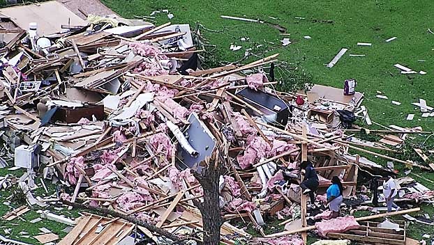
- Aerial photos showing damage in Jefferson Davis County, courtesy MEMA
Two of the nine known tornadoes that ripped through Mississippi Easter Sunday were monster storms, the National Weather Service reported Wednesday, the largest being at least 2 miles wide, with winds of more than 166 mph, cutting a path more than 67 miles long.
“To put the ‘at least 2 mile width’ into perspective, the widest tornado ever surveyed was the May 31, 2013, tornado near El Reno, OK at 2.6 miles wide,” the National Weather Service wrote in an update.
The two monster, long-track tornadoes, one estimated to be an EF4, the other an EF-3, were on the ground for more than an hour each. One tore a path of destruction for more than 82 miles, the other more than 67 miles.
The last known death toll was 12, with dozens more injured, some critically.
The National Weather Service’s Jackson office released preliminary data on nine of the Easter Sunday tornadoes.
NWS forecasters say survey crews are still out working and what is below are only estimates which may change over time.
Here are the preliminary stats:
Humphreys County: EF1
Estimated Peak Wind: 110 mph
Path Length /statute/: 4.12 miles
Path Width /maximum/: 440.0 yards
Fatalities: 0
Injuries: 0
On ground for approximately 5 minutes
Yazoo County: EF2
Estimated Peak Wind: 120 mph
Path Length /statute/: 7.42 miles
Path Width /maximum/: 250.0 yards
Fatalities: 0
Injuries: 0
On ground for approximately 10 minutes
Sallis (Attala County): EF1
Estimated Peak Wind: 92 mph
Path Length /statute/: 2.55 miles
Path Width /maximum/: 500.0 yards
Fatalities: 0
Injuries: 0
On ground for approximately 3 minutes
Choctaw County: EF0
Estimated Peak Wind: 75 mph
Path Length /statute/: 3.06 miles
Path Width /maximum/: 150.0 yards
Fatalities: 0
Injuries: 0
On ground for approximately 4 minutes
North Macon (Noxubee County): EF2
Estimated Peak Wind: 125 mph
Path Length /statute/: 8.69 miles
Path Width /maximum/: 1100.0 yards
Fatalities: 0
Injuries: 0
On ground for approximately 10 minutes
Bigbee Valley (Noxubee County): EF1
Estimated Peak Wind: 88 mph
Path Length /statute/: 3.91 miles
Path Width /maximum/: 375.0 yards
Fatalities: 0
Injuries: 0
On ground for approximately 6 minutes
Lawrence/Marion/Jeff Davis counties: EF2
Estimated Peak Wind: 130 mph
Path Length /statute/: 14.54 miles
Path Width /maximum/: 1320.0 yards
Fatalities: 2
Injuries: 0
On ground for approximately 19 minutes
Tornado tossed and destroyed a mobile home, causing two fatalities.
Tornado started in Walthall County (which is tracked by the National Weather Service’s New Orleans office. Combined, the total path length from the start point in Walthall County to the end in Jefferson Davis County was approximately 21.2 miles.
Jefferson Davis to Clarke County: EF4
Estimated Peak Wind: N/A
Path Length /statute/: 67.77 miles
Path Width /maximum/: 3520.0 yards (2 miles)
Fatalities: 0
Injuries: 0
On ground for approximately 1 hour, 17 minutes
Lawrence to Jasper County: EF3
Path Length /statute/: 82.61 miles
Path Width /maximum/: 1800.0 yards (1 mile)
Fatalities: 0
Injuries: 0
On ground for approximately 1 hour, 31 minutes
EF Scale: The Enhanced Fujita Scale classifies tornadoes into the
following categories.
EF0…Weak……65 TO 85 mph
EF1…Weak……86 TO 110 mph
EF2…Strong….111 TO 135 mph
EF3…Strong….136 TO 165 mph
EF4…Violent…166 TO 200 mph
EF5…Violent…Above 200 mph