Mississippi tornado outbreak: National Weather Service says 12 tornadoes confirmed, two monster storms
Published 11:07 am Thursday, April 16, 2020
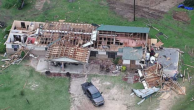
The National Weather service has updated its statistics for the Easter Sunday tornado outbreak. In total, 12 tornados have been confirmed, two of which were rated as EF-4, with winds between 166 mph and 200 mph.
One of the tornadoes is believed to be the widest tornado ever recorded in Mississippi, with a width of at least 2 miles across.
That tornado breaks the previous record set by the April 24, 2010 tornado that tracked struck Yazoo City. The Yazoo City tornado had a measured width of 1.75 miles across.
The widest storm ever recorded in the U.S. was the May 31, 2013, tornado near El Reno, OK at 2.6 miles wide, the National Weather Service wrote in an update.
Two of Sunday’s storms were considered “long-track” storms that were on the ground for more than 25 miles. One tornado tore a path of destruction for more than 82 miles, the other more than 67 miles.
The last known death toll was 12, with dozens more injured, some critically.
The National Weather Service’s Jackson office released preliminary data on nine of the Easter Sunday tornadoes.
NWS forecasters say survey crews are still out working and what is below are only estimates which may change over time.
Here are the preliminary stats:
Humphreys County: EF1
Estimated Peak Wind: 110 mph
Path Length /statute/: 4.12 miles
Path Width /maximum/: 440.0 yards
Fatalities: 0
Injuries: 0
On ground for approximately 5 minutes
Yazoo County: EF2
Estimated Peak Wind: 120 mph
Path Length /statute/: 7.42 miles
Path Width /maximum/: 250.0 yards
Fatalities: 0
Injuries: 0
On ground for approximately 10 minutes
Sallis (Attala County): EF1
Estimated Peak Wind: 92 mph
Path Length /statute/: 2.55 miles
Path Width /maximum/: 500.0 yards
Fatalities: 0
Injuries: 0
On ground for approximately 3 minutes
Choctaw County: EF0
Estimated Peak Wind: 75 mph
Path Length /statute/: 3.06 miles
Path Width /maximum/: 150.0 yards
Fatalities: 0
Injuries: 0
On ground for approximately 4 minutes
North Macon (Noxubee County): EF2
Estimated Peak Wind: 125 mph
Path Length /statute/: 8.69 miles
Path Width /maximum/: 1100.0 yards
Fatalities: 0
Injuries: 0
On ground for approximately 10 minutes
Bigbee Valley (Noxubee County): EF1
Estimated Peak Wind: 88 mph
Path Length /statute/: 3.91 miles
Path Width /maximum/: 375.0 yards
Fatalities: 0
Injuries: 0
On ground for approximately 6 minutes
Lawrence/Marion/Jeff Davis counties: EF4
Estimated Peak Wind: 170 mph
Path Length /statute/: 21.2 miles
Path Width /maximum/: 3/4 mile
Fatalities: 2
Injuries: 0
On ground for approximately 26 minutes
Tornado tossed and destroyed a mobile home, causing two fatalities.
Jefferson Davis to Clarke County: EF4
Estimated Peak Wind: N/A
Path Length /statute/: 67.77 miles
Path Width /maximum/: 3520.0 yards (2 miles)
Fatalities: 0
Injuries: 0
On ground for approximately 1 hour, 17 minutes
Lawrence to Jasper County: EF3
Path Length /statute/: 82.61 miles
Path Width /maximum/: 1800.0 yards (1 mile)
Fatalities: 0
Injuries: 0
On ground for approximately 1 hour, 31 minutes
East Pachuta (Clarke County): EF1
Estimated Peak Wind: 100 mph
Path Length /statute/: 7.79 miles
Path Width /maximum/: 250.0 yards
Fatalities: 0
Injuries: 0
On ground for approximately 10 minutes
Stonewall/East Enterprise (Clarke County): EF2
Estimated Peak Wind: 130 mph
Path Length /statute/: 3.43 miles
Path Width /maximum/: 300.0 yards
Fatalities: 0
Injuries: 2
On ground for approximately 4 minutes.
Clarkdale (Lauderdale County): EF1
Estimated Peak Wind: 95 mph
Path Length /statute/: 3.03 miles
Path Width /maximum/: 300.0 yards
Fatalities: 0
Injuries: 0
On ground for approximately 2 minutes
EF Scale: The Enhanced Fujita Scale classifies tornadoes into the
following categories.
EF0…Weak……65 TO 85 mph
EF1…Weak……86 TO 110 mph
EF2…Strong….111 TO 135 mph
EF3…Strong….136 TO 165 mph
EF4…Violent…166 TO 200 mph
EF5…Violent…Above 200 mph