Expected severe weather Sunday in Mississippi may include tennis ball size hail, possible tornadoes
Published 3:13 pm Friday, April 17, 2020
A repeat of the ferociousness of the tornado outbreak during the Easter weekend of 2020 is not anticipated, but a new round of severe weather, including the potential for tornadoes, seems likely to target many of the same areas hit hard recently in the southern United States.
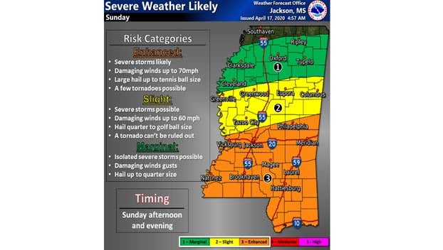
The National Weather Service’s Jackson, Mississippi, office reports, “Severe thunderstorms are likely Sunday afternoon into Sunday evening. The main threat will be for damaging winds up to 60-70mph, large hail up to tennis ball size, and a few tornadoes.
In addition, forecasters said between 1 and 3 inches of rain may fall over certain parts of the Magnolia State with the greatest chance being, generally along the I-20 corridor and south.
Many communities in the South are cleaning up and beginning to pick up the pieces following a major outbreak of violent weather that struck Saturday, April 11, to Monday, April 13, and triggered approximately 960 incidents of severe weather, including more than 140 tornado reports. Severe weather incidents were reported in every state in the South. The storms claimed the lives of at least 34 people across six states. The pandemic and social distancing measures have been complicating an already difficult time in the aftermath of the devastating storms.
“We saw more tragedy in the midst of what is already one of the most trying times our state has endured,” South Carolina Gov. Henry McMaster said over social media, referencing dealing with the severe weather amid the COVID-19 pandemic.
“This environment has come with some unique complications, but the Red Cross is practicing social distancing just like the rest of the nation,” Stephanie Wagner, spokesperson for the American Red Cross told AccuWeather’s Brittany Boyle in a TV interview.
“Our goal is to support people in their time of need after a disaster, to provide comfort, care and hope. And in this time with this COVID-19 environment, we’re adjusting some of our service delivery to be done so in a virtual capacity, providing things like financial assistance, mental health,” Wagner said, adding that the Red Cross has not opened shelters for victims and instead has focused on getting people shelter through hotels, dormitories, etc.
A storm system forecast to bring a modest amount of rain and mountain snow to California into Friday night will make the difficult trek across the southern Rockies and is likely to reorganize upon nearing the lower Mississippi Valley this weekend.
The fast-moving storm will then begin to tap moisture from the Gulf of Mexico and pump warm and humid air over the South Central and Southeast states.
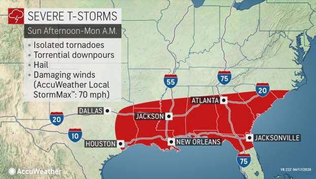
“All forms of severe weather are anticipated with the event that is forecast to span Sunday into early Monday in the South,” AccuWeather Senior Meteorologist Rob Miller said.
“The strongest storms will have the potential to bring wind gusts to 70 mph, flash flooding, large hail and perhaps even a tornado during the upcoming severe weather outbreak,” Miller said.
Adding to the danger will be the risk that some of the tornadoes could be wrapped in rain or may occur after dark.
AccuWeather meteorologists do not believe the number of tornadoes with the upcoming event will come close to the dozens of tornadoes that were spawned with the major outbreak during the 2020 Easter weekend. However, all it takes is for one tornado to strike a community to cause widespread destruction and potentially cause loss of life. And the event from Sunday to Sunday night is still likely to produce multiple tornadoes.
By Monday morning, the storms will have reached the southern Atlantic coast where the main threats will be from damaging wind gusts and flash flooding. The storm system is forecast to race offshore by the afternoon.
The overall strength of this storm system will pale in comparison to the powerful storm that traveled from the Deep South to the Great Lakes and southeastern Canada last weekend, so a broad area of high winds outside of thunderstorms is not expected to affect northern locations.
The fast-moving severe weather event is also likely to be somewhat more compact in nature, when compared to the Easter weekend outbreak. Severe weather is not expected to reach into the middle Mississippi and Ohio valleys or the mid-Atlantic region. The severe weather risk from Sunday to Monday is forecast to extend from northeastern Texas to northern Florida, Georgia, South Carolina and southern North Carolina.
Even though the upcoming event may not have the coverage or perhaps the intensity of the Easter weekend outbreak, people are encouraged to take all severe weather events seriously and have a plan of action in place prior to the arrival of a severe thunderstorm. Doing so could save valuable seconds and ultimately prove to be life-saving.
Article by Accuweather