Threat of severe weather returns to Mississippi Wednesday, Thursday
Published 10:01 am Tuesday, April 21, 2020
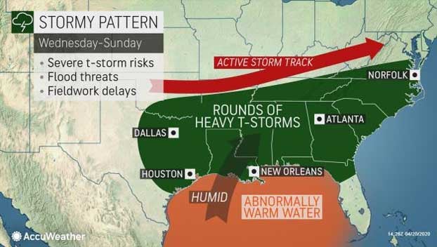
It has been a very active stretch of severe weather across the South this April, with two major severe weather producers in as many weeks. Unfortunately, the threat for all modes of severe weather will ramp up once again at midweek.
Communities that were ravaged by powerful wind gusts, large hail and flooding across the South on Sunday will have a very limited window of time to clean up and prepare for the upcoming system beginning on Wednesday.
To add to the stress of thunderstorm cleanup, recovery efforts have been complicated by COVID-19 precautionary measures.
Although the window for cleanup will be brief, dry and settled conditions are expected across the South into Tuesday as an area of high pressure settles in.
While the South remains under high pressure on Tuesday, the atmospheric disturbance that will eventually spark the severe threat across the South will track into the southern Plains, bringing a localized threat for severe weather.
As the disturbance tracks into the southern Plains into the day on Wednesday, it will be able to draw in warm and humid air out of the Gulf of Mexico, adding in the ingredients necessary for more widespread severe thunderstorm development.
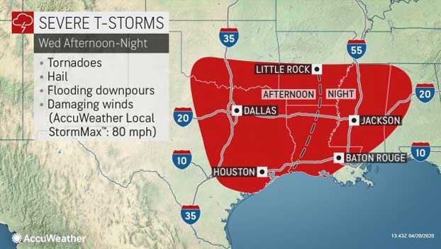
Showers and thunderstorms are expected to form prior to Wednesday across portions of northern Texas and Oklahoma, but the threat for severe weather will increase during Wednesday as the atmosphere destabilizes.
After severe thunderstorms brought hail and damaging wind gusts to the Dallas-Fort Worth Metroplex on Sunday, severe thunderstorms may once again target the area on Wednesday.
Depending on the exact track of the storm system at midweek, this upcoming severe weather threat may extend farther north compared to Sunday’s severe weather event. Oklahoma City, Little Rock, Arkansas, and Memphis, Tennessee, may face the threat for severe weather if the center of the storm system stays far enough north.
The storm system is expected to have enough energy available to continue to produce severe weather into Wednesday night. Both storm and flood-weary Jackson, Mississippi, and Tuscaloosa, Alabama, will once again be in line for additional thunderstorm activity Wednesday night.
Into the day on Thursday, feisty thunderstorms are expected to continue to track eastward.
Much of the Southeast will be next in line for the threat of damaging wind gusts, flash flooding, hail and even a few tornadoes.
Macon, Georgia; Tallahassee, Florida, Myrtle Beach, South Carolina, and all areas in between could face another threat for severe thunderstorms.
The risk of severe weather is also likely to expand northward on Thursday and Thursday evening. This risk will include middle and eastern Tennessee as well as the lower part of the mid-Atlantic coast.
The risk of flooding rainfall will focus near and north of the core of severe weather.
Although traffic remains generally light with many people working remotely, or not at all due to the COVID-19 pandemic, remaining motorists traveling along interstates 10, 20, 65, 75 and 95 across the Southeast can expect to keep the windshield wipers on high as showers and thunderstorms track through the region.
The threat for severe weather is expected to largely clear off the Atlantic coast by Thursday night, allowing for dry conditions to return.
Unfortunately across the South, the weather pattern looks to remain active, as additional chances for showers and thunderstorms are expected to return this weekend.
Severe weather is likely to be a frequent visitor to the South Central and Southeast states well into May.
By Brandon Buckingham, AccuWeather Meteorologist, originally published here.