Be alert Mississippi: More severe weather, possible tornadoes headed to South
Published 6:53 am Tuesday, April 28, 2020
More severe thunderstorms, including the likelihood of tornadoes, are anticipated for the southern and central United States this week as 2020 continues on a trend to be among the top years for tornadoes.
Meteorologists have been monitoring a potent storm system expected to pivot from the Canada Rockies to the Plains, Mississippi Valley and Appalachians for the potential to ignite another outbreak of severe thunderstorms Tuesday to Wednesday night.
Nearly 50 million Americans live in the severe thunderstorm risk zone for the two-day outbreak. Those venturing outdoors or staying at home will need to closely monitor the weather situation for the potential for rapidly-changing and dangerous conditions.
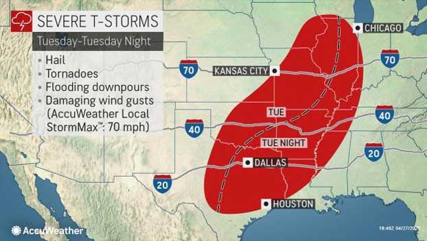
During Tuesday, thunderstorms will extend along an approximate 1,100-mile swath from northern Illinois to central Texas and includes the full spectrum of severe weather ranging from large hail and flash flooding to damaging wind gusts and tornadoes.
“One area to watch for tornadoes on Tuesday will stretch from eastern Iowa and northeastern Missouri to northern and central Illinois,” AccuWeather reporter Blake Naftel said.
“There is a risk of a scattering of discrete storms erupting along a warm front and potentially evolving into severe, tornado-producers ahead of the main line of thunderstorms from the push of cooler air,” he explained.
Another area that will need to be closely monitored during the afternoon hours will be in places like Oklahoma City and Tulsa. Explosive thunderstorm development will likely lead to a threat for very large hail, damaging wind gusts and even a tornado or two.
This includes stretches of Interstates 35, 40 and 44 in central and eastern Oklahoma.
Into the overnight hours, it is quite possible that thunderstorms congeal into a massive line of damaging straight-line wind producing thunderstorms. This complex of thunderstorms will then blast southeastward into neighboring Arkansas, Louisiana and eastern Texas.
The line of storms is then expected to continue to feed on the very unstable atmospheric conditions in place across the South, allowing a severe threat to continue right into Wednesday morning.
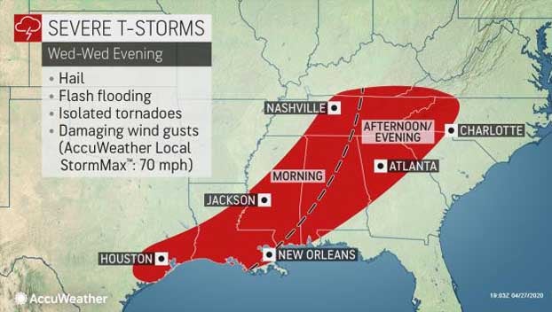
“On Wednesday, the zone of severe thunderstorms, including the potential for tornadoes, is forecast to extend from part of the Ohio Valley to the central Gulf coast,” AccuWeather Senior Meteorologist Brett Anderson said.
During the afternoon and evening hours on Wednesday, the risk of severe storms will extend from portions of the mid-South to southeastern Louisiana and the panhandles of Mississippi, Alabama and Florida.
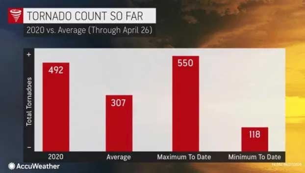
The tornado count for 2020 was 492 as of April 26, and this year is on pace to rank among top years for twisters.
The number of tornadoes has surpassed the 75th percentile ranking and is closing in on the 90th percentile. The preliminary tornado report toll may change as investigation continues by the National Weather Service (NWS).
Since the 1950s, the year 2011 brought the most tornadoes on record with 1,894 twisters based on data from the Storm Prediction Center (SPC). The year 2004 yielded 1,820 tornadoes.
There have been 73 fatalities in 2020, as of mid-April.
This compares to 553 fatalities in all of 2011, which was the second deadliest year for tornadoes on record. The most tornado-related deaths occurred in 1925, which was prior to the satellite and radar era.
During 1925, the Tri-State Tornado accounted for 695 fatalities alone. The March 18, 1925, twister was on the ground for 219 miles and traveled through the states of Missouri, Illinois and Indiana.
While there may be a bit more separation between major storms in the wake of the severe weather from Tuesday and Wednesday, additional systems will continue to move through every several days with new threats during May.
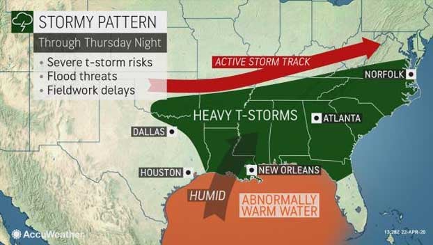
The path of the parent storm this week is somewhat different from the track of other storms that have unleashed severe weather so far this spring. Most storms have moved out of the southwestern U.S. or moved up from the Gulf of Mexico.
The direction from which the parent storm comes from matters little, but a stream of warm, moist air from the Gulf of Mexico is often a major contributor to severe weather outbreaks, and that parameter will be tapped by this storm system.
Another major role in severe weather is played by the jet stream. When the jet stream is strong, as it almost always is during the spring and early summer, thunderstorms get an added boost of intensity.
By Alex Sosnowski, AccuWeather senior meteorologist