Hurricane watches go up after Beta grows in Gulf
Published 11:40 am Saturday, September 19, 2020
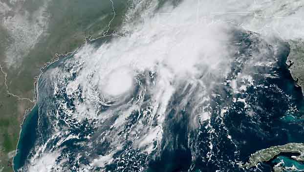
Beta spurs hurricane watch for Texas, expected to strengthen
An exceptionally busy Atlantic hurricane season was churning along Saturday as the Texas coast prepared for a tropical storm that’s forecast to strengthen into a hurricane before breaching its shores in the week ahead.
Both the city of Galveston and Galveston County on Saturday issued voluntary evacuation orders ahead of Tropical Storm Beta.
Mayor Pro Tem Craig Brown said in a statement that high tides and up to 10 inches of expected rainfall would leave roads impassable, especially along the city’s west end and low-lying areas.
County Judge Mark Henry said during a Saturday news conference that his concern is also based on rising waters creating a storm surge and that a mandatory evacuation is not expected.
“If you can survive in your home for three or four days without power and electricity, which we’re not even sure that’s going to happen, you’re OK,” Henry said. “If it’s uncomfortable or you need life support equipment, maybe go somewhere else.”
Tropical Storm Beta was brewing in the Gulf of Mexico, 305 miles (495 kilometers) east-southeast of Corpus Christi, Texas, and 245 miles (395 kilometers) south of Lake Charles, Louisiana, the U.S. National Hurricane Center said in an advisory. The system was forecast to become a hurricane on Sunday and triggered a tropical storm warning from Port Aransas, Texas, to Intracoastal City, Louisiana.
Also in effect were a storm surge watch from Port Mansfield, Texas to Cameron, Louisiana; and a tropical storm watch from south of Port Aransas to the mouth of the Rio Grande, and east of High Island to Morgan City, Louisiana.
Beta had maximum sustained winds at 60 mph (95 kph) and was moving northwest at 3 mph (6 kph).
Forecasters were predicting up to 4 feet (1.2 meters) of storm surge along parts of the Texas coast that included Baffin Bay, Corpus Christi Bay, Galveston Bay and more. Wind, heavy rainfall and life-threatening surf and rip current conditions were also expected with the storm.
Forecasters ran out of traditional storm names on Friday, forcing the use of the Greek alphabet for only the second time since the 1950s.
Meanwhile, Hurricane Teddy remained a powerful hurricane Saturday, with maximum sustained winds at 120 mph (195 kph) and moving northwest at 14 mph (22 kph). Teddy was centered 560 miles (900 kilometers) southeast of Bermuda less than a week after Hurricane Paulette made landfall in the wealthy British territory.
A tropical storm warning was in effect for Bermuda. Large swells from Teddy were forecast to impact the Lesser Antilles, the Greater Antilles, the Bahamas and Bermuda, and were expected to impact the U.S. East Coast.
Parts of the Alabama coast and Florida Panhandle were still reeling from the effects of Hurricane Sally, which roared ashore on Wednesday. At least two deaths were blamed on the system, and hundreds of thousands of people were still without power late Friday.
Alpha dissipated Friday night after bringing rain to Portugal. Tropical Storm Wilfred remained at sea but was not expected to impact land.