Hurricane Delta strengthens back up to Category 3, churns toward U.S. landfall
Published 10:23 pm Thursday, October 8, 2020
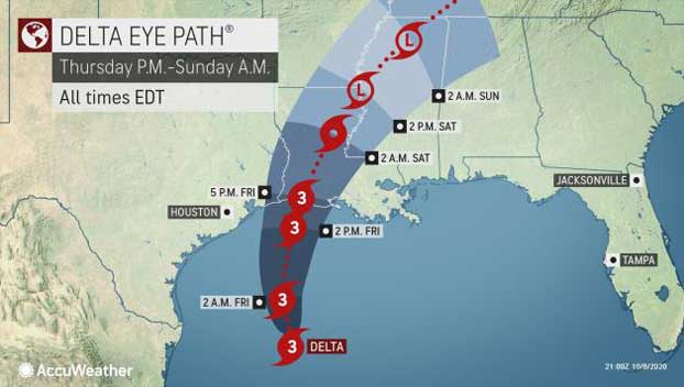
Hurricane Delta has restrengthened into a Category 3 storm packing maximum sustained winds of 115 mph over the warm waters of the Gulf of Mexico. At 4 p.m. CDT Thursday, Delta was upgraded to major hurricane status after NOAA’s Hurricane Hunters flew through the storm and found that it was strengthening — and it could remain a major hurricane as it charges toward landfall in southwestern Louisiana late Friday as the 10th storm to strike the United States this hurricane season.
At 7 p.m. CDT Thursday, Delta was churning about 310 miles south of Cameron, Louisiana, the town where Hurricane Laura made a devastating landfall in late August. Its forward speed was starting to slow, and the storm was moving northwestward at 12 mph Thursday afternoon as it prepared to take more of a northward turn and head straight for the hurricane-battered coastline.
The turn to the north is forecast to occur Thursday and Thursday night, with the likelihood of a turn more to the northeast on Friday. The predicted track places communities from southwestern to south-central Louisiana in the path of the worst conditions forecast. The core of the hurricane’s wind, rainfall and storm surge would be steered east of Texas with the anticipated path.
However, forecasters said Delta’s rain and wind field will continue to grow in size and strength as the hurricane continues to move along at a steady pace.
Squalls containing torrential downpours, gusty winds and even severe thunderstorms will increase in frequency along the northwestern and central Gulf coast area of the U.S. as seas and surf build into Friday.
A rise in water levels began along the upper Gulf on Thursday morning, and levels will continue to ratchet up into Friday afternoon and evening, especially from Alabama through Louisiana.
“We expect Delta to reach the coast of southwestern Louisiana near or just east of Cameron, Louisiana, between 3 p.m. and 6 p.m. CDT Friday as a Category 3 hurricane,” AccuWeather’s top hurricane expert Dan Kottlowski stated. A Category 3 hurricane has maximum sustained winds of 111-129 mph.
Delta is forecast to undergo some weakening just prior to making landfall in the U.S. late Friday, but a strike by a major hurricane is still expected in Louisiana. The storm has been rated a 3 on the AccuWeather RealImpact™ Scale for Hurricanes based on anticipated storm surge, high winds, flooding rainfall and a number of other economic factors. This scale, developed by AccuWeather, provides a more comprehensive outlook for impacts from tropical storms and hurricanes on land areas than the Saffir-Simpson Hurricane Wind Scale, which is based solely on wind speed.
During Friday afternoon and evening, as Delta moves onshore, life-threatening storm surge, destructive winds and torrential rainfall will commence along the south-central and southwestern Louisiana coast.
“Delta is expected to bring a very dangerous maximum storm surge of 6-10 feet with the highest values near and to the right of where the hurricane makes landfall, especially for inlets and bays where water can become funneled, creating a rapid rise in water levels,” Kottlowski said.
The forecast track should keep the worst impacts west of New Orleans, but communities from Lake Charles to Lafayette, Louisiana, can be hit especially hard with extensive property damage and power outages from a combination of high winds, torrential rain and flooding along this portion of the Interstate-10 corridor in Louisiana.
“The strongest wind gusts of 120-130 mph will occur near and just to the east of where Delta makes landfall, with an AccuWeather Local StormMax™ of 140 mph,” Kottlowski said.
Hurricane-force wind gusts of greater than 74 mph can extend inland through much of south-central Louisiana.
“The strength of the wind will lead to widespread damage to trees, power lines, weaker buildings, roofing and structures, including in some of the same areas impacted by Hurricane Laura in late August,” Kottlowski explained.
Trees may block streets and secondary roads in the aftermath of the hurricane, with power outages expected to last many days, if not weeks, in some of the hardest-hit communities.
Rainfall on the order of 4-8 inches will be widespread over central Louisiana. Delta’s fast pace should prevent a repeat of staggering rainfall amounts and flooding from Harvey in 2017 or a lesser extent from Marco, Sally and Beta this year.
“An AccuWeather Local StormMax™ of 12 inches in southwestern and central Louisiana, which can lead to widespread flooding,” Kottlowski warned.
The bulk of the rain and wind will occur from Friday afternoon to Saturday midday in Louisiana. Forecasters and officials urged residents to heed all warnings during and after the height of the storm, including staying off roads as the storm rages through the region.
In addition to the threats from storm surge, high winds and flooding rainfall, there is the potential for tornadoes near and east of the center of Delta as it makes landfall and moves inland.
The greatest risk of tornadoes will occur from south-central Louisiana to southern Mississippi and perhaps the Alabama Panhandle. The thunderstorms capable of spawning tornadoes can be fast-moving. Any tornado can strike with very little to no notice.
While the water is warm over much of the Gulf of Mexico, it is not quite as warm as that of the northwestern Caribbean, where rapid strengthening occurred earlier this week. However, the water over the central Gulf of Mexico is warm enough to allow re-strengthening and perhaps rapid re-strengthening for a time. Thus, forecasters and officials alike say Delta should be considered a dangerous threat to the U.S.
On Tuesday, Delta’s intensification was the most extreme in 15 years for an October hurricane. The storm’s maximum sustained winds increased by a whopping 70 mph — from 40 mph to 110 mph — in its first 24 hours as a named storm. Only Hurricane Wilma in 2005 exploded in a more significant fashion over that same 24-hour period. Delta has also set a speed record for strengthening from a depression to a Category 4 hurricane. Delta accomplished this in just over 36 hours, surpassing Keith from 2000, which did so in 42 hours.
Hurricane Delta quickly strengthened into the second-most intense hurricane of the 2020 Atlantic hurricane season on Tuesday as its maximum sustained winds reached 145 mph. The only storm to become stronger this season was Hurricane Laura, which packed peak winds of 150 mph.
Along the Gulf Coast, Delta is expected to behave differently than Laura from August. Laura was strengthening upon landfall and reached Category 4 force before roaring ashore.
“As Delta approaches the upper Gulf Coast, it will start to encounter increasing wind shear and slightly cooler water, which should wear on the storm and start a weakening process,” according to Kottlowski.
Wind shear is the increase in wind speed with altitude as well as the sudden change in wind direction from one location to another. Wind shear and changes in the structure of the eye are some of the main challenges in forecasting the overall strength of hurricanes.
“The forward speed of Delta and the degree of shear it encounters will determine its wind strength at landfall late Friday,” Kottlowski explained.
By Alex Sosnowski, AccuWeather senior meteorologist & Meghan Mussoline, AccuWeather meteorologist, originally published: https://www.accuweather.com/en/hurricane/hurricane-delta-to-strengthen-as-it-blitzes-across-gulf-of-mexico/826642