Severe weather possible on New Year’s Eve in Mississippi
Published 9:00 am Tuesday, December 29, 2020
Parts of Mississippi may see severe weather on the last day of 2020 as a storm system moves through the region.
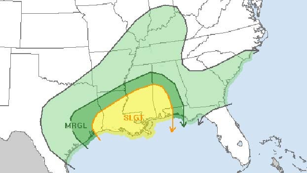
The National Weather Service’s Storm Prediction Center has much of the southern half of Mississippi forecast with a slight risk for severe weather on Thursday and a marginal risk over the central part of the state.
A slight risk is Level 2 out of 5 and means scattered severe storms will be possible. A marginal risk is Level 1 and means the severe storms could be more isolated.
The threat for #severe weather remains in place for this Thursday (New Year’s Eve). Review your plans, and remain weather aware heading into the year’s last holiday. #lawx #mswx #arwx pic.twitter.com/rYacAJyg3l
— NWS Jackson MS (@NWSJacksonMS) December 29, 2020
Severe thunderstorms, capable of producing damaging wind gusts and tornadoes, are possible on New Year’s Eve across portions of central and southern Mississippi.
The main time-frame for the severe weather will be late Thursday morning into late Thursday night.
Becasue storms could affect parts of the state during the overnight hours, it will be important to have a way to get weather warnings at all hours of the night.
Heavy rain could be an issue statewide, and the weather service said 1 to 3 inches will be possible through Friday evening.
Forecasters also expect it to be windy, even away from storms. The weather service said 30 to 40 mph wind gusts won’t be out of the question on Thursday into Friday.
The best chances of seeing strong storms will be across south Mississippi, according to the weather service, but isolated strong to severe storms will be possible across much of the rest of the state as well.