Severe weather risk on New Year’s Eve upgraded for parts of Mississippi
Published 4:35 pm Wednesday, December 30, 2020
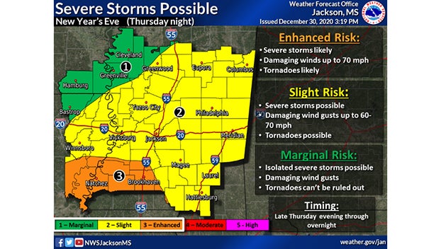
The severe weather risk for New Year’s Eve has been upgraded to an “Enhanced” level for parts of Mississippi.
Counties in the southwest corner of the state, including Adams, Wilkinson, Franklin, Amite, Lincoln and other counties can expect severe thunderstorms, capable of producing damaging wind gusts and tornadoes.
The storm system is expected to move into the region Thursday evening(New Year’s Eve) and continue to spread northeast across the state overnight.
The rest of Central Mississippi is included in the Level 2 “Slight” risk.
Clouds are expected for the morning hours on Thursday, but then storms begin by mid-afternoon. The first round of storms could move through Southwest Mississippi early Thursday evening. A second broken line of storms is expected to push through later in the evening with damaging winds and the potential for an embedded tornado.
The highest risk for a tornado will be in the orange shading from Natchez to Brookhaven to McComb, but a tornado cannot be ruled out for anyone.


