National Weather Service releases forecast timeline for New Year’s Eve storm system
Published 3:40 pm Thursday, December 31, 2020
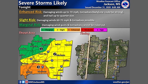
The National Weather Service in Jackson said Mississippi residents can expect a strong storm system to enter the western edge of the state at approximately 6 p.m. NWS released a timeline of today’s approaching weather system, alert residents to be aware of the possibility of severe weather, including hail, strong winds and tornadoes.
The western portion of the state will begin to see storms between 6 p.m. and 10 p.m. Areas east of Jackson will begin to see storms after midnight.
A tornado watch has already been issued for portions of Louisiana until 9 p.m. Thursday evening. The watch area could be extended into parts of Mississippi as the storm system moves across the region.
Here is a look at the timing for the weather tonight. Check your safety plan and stay weather aware as you ring in the New Year tonight! pic.twitter.com/rOWMOHIbOx
— NWS Jackson MS (@NWSJacksonMS) December 31, 2020