Special Weather Briefing: Prepare for ice, snow, dangerous cold temps for much of state
Published 4:40 pm Friday, February 12, 2021
The National Weather Service in Jackson issued a special weather briefing Friday evening with details about the winter weather forecast for the weekend into the early part of next week.
Light freezing rain or freezing drizzle, resulting in light icing of bridges and overpasses, is possible over western and northern portions of the ArkLaMiss region tonight into Saturday morning and again Saturday night into Sunday Morning.
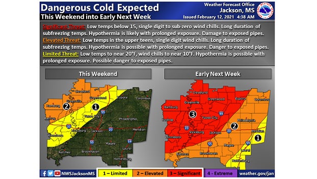
Arctic air is expected to begin reaching the area this weekend, with the coldest surge of frigid air early next week. This could end up being a long duration of very cold conditions and dangerous wind chill readings.
A significant winter weather event is expected Monday into Monday night. Significant ice and sleet accumulations will result in dangerous travel conditions as well as downed trees and power lines.
A Winter Storm Watch is in effect from Sunday afternoon through late Monday night.
A Winter Storm Watch means there is a potential for significant snow, sleet, or ice accumulations that may impact travel. Continue to monitor the latest forecasts.
Heavy mixed precipitation is possible. Total snow accumulations of up to two inches and ice accumulations of around one quarter of an inch possible for portions of northeast Louisiana, central, north
central, northeast, northwest, south-central, southwest and west-central Mississippi and southeast Arkansas.
From Sunday afternoon through late Monday night. Some accumulation may occur Sunday afternoon, but the biggest accumulations and impacts will occur Sunday night into Monday.
Plan on slippery road conditions. The hazardous conditions could impact the morning or evening commute. The cold wind chills as low as 5 below zero could result in hypothermia if precautions are not taken.