Mississippi in path of severe weather threat, major rainfall, tornadoes, hurricane-force winds possible
Published 11:28 am Wednesday, March 24, 2021
A week after an outbreak of severe weather and tornadoes sent Americans seeking shelter across the South, back-to-back storm systems are expected to unleash excessive rainfall over the south-central United States. AccuWeather forecasters say rainfall could total more than a foot over the course of a few days and trigger the threat of flooding. Communities still picking up the pieces after last week’s destructive weather could face flood concerns and the return of severe weather.
“It will be the second of the two storms expected to swing through the South starting at the middle of this week that appears like it will be the most potent and may cause the most trouble in terms of flooding and perhaps severe thunderstorms,” AccuWeather Chief On-Air Meteorologist Bernie Rayno said.
Over much of the Plains and Midwest, aside from typical issues with urban flooding, rain will be spread out enough over a few days and should prevent widespread flooding problems.
As the first storm system encountered Gulf of Mexico moisture into Tuesday night, gusty and locally drenching thunderstorms led to incidents of flash and urban flooding along the northern part of the Gulf coast.
National Weather Service hydrological data indicated that the Contraband Bayou near Lake Charles, Louisiana, rose rapidly to major flood stage on Tuesday morning in response to heavy rainfall. Flood stage for the site is 8 feet, but the level had reached 12 feet at the start of the day on Tuesday. Major flooding begins at 10 feet. More incidents such as this are anticipated in the coming days from the Mississippi River Delta region through the Tennessee Valley.
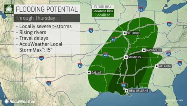
Rainfall from the second of the two storms will arrive a day or two later in parts of Louisiana, Mississippi, Alabama, Arkansas and Tennessee. The new surge of wet weather is forecast to be intense and persistent enough to raise the risk of small stream flooding and rises on the rivers, in addition to the likelihood of urban flooding.
“In the Interstate 10, 20 and 40 corridors in the Mississippi Delta and lower Mississippi Valley region, a general 4-8 inches of rain is anticipated during the middle days of this week, with the bulk of that rain expected to fall from Wednesday to Thursday,” AccuWeather Senior Meteorologist Brett Anderson said.
Where the heaviest rain pours down and repeats, an AccuWeather Local StormMax™ of 15 inches is anticipated.
Long-term rainfall amounts in much of this zone have not been remarkable, but recent rainfall may have primed the landscape for potential flooding. In some communities, rainfall has been well below normal since the start of the new year. Between Jan. 1 and March 23, Jackson, Mississippi, picked up 10.27 inches of rain compared to a normal amount of 13.40 inches. During the same time, Birmingham, Alabama, had 12.22 inches of rain, coming in under the normal of 13.30 inches.
Even though prevailing soil conditions were average to dry prior to last week’s rain, localized flooding problems developed in portions of Mississippi, Alabama, Tennessee and Arkansas, according to Rayno.
The near- to below-average rainfall during the first three months of the year has left some areas abnormally dry, according to data from the United States Drought Monitor released on March 18. However, rainfall from last week alone was anywhere from two to five times that of average. The bulk of the rain last week fell in two days — on March 16 and 17.
For example, Meridian, Mississippi, received 4.42 inches of rain on March 16 and 17, compared to a normal of 1.21 inches of rain for the third week of the month. Meridian is within the zone of anticipated heaviest rainfall at midweek.
Birmingham and Huntsville, Alabama, are forecast to be within the zone of the potentially excessive rainfall this week, and both locations received about 4.5 inches of rain on March 16 and 17.
Other cities that have the potential to experience problems from excessive rainfall this week include Memphis and Nashville, Tennessee; Little Rock, Arkansas; Jackson and Tupelo, Mississippi; and New Orleans and Baton Rouge, Louisiana.
“With bigger rain forecast for this week on roughly the same areas that were hit last week, there may be more significant and perhaps more widespread problems due to flooding,” Rayno added.
Some rivers in the region that could experience significant rises during the middle and latter part of this week after runoff flows downstream from smaller tributaries including the Pearle, Alabama, Tennessee, Yazoo, Chickasawhay and Tombigbee.
Water levels on the lower portions of the Chickasawhay and Tombigbee rivers were at minor flood stage and cresting early this week, according to National Weather Service hydrological data. The surge of water was from last week’s rainfall.
The same pattern that brought heavy rain and flash flooding last week also produced 245 incidents of severe weather, including 54 reports of tornadoes on March 16 and 17. The outbreak continued on March 18 but was focused along the southern Atlantic seaboard.
Alabama was dealt some of the most destructive severe weather last week. An EF2 tornado touched down in Chilton County on Wednesday, spawning 130-mph winds. An EF1 tornado packing 110-mph winds struck Moundville, Alabama, causing severe damage to buildings and ripping roofs off homes.
Officials and the National Weather Service credited preparation and the actions of residents when warnings were issued in the path of severe weather with the fact that no fatalities occurred amid the outbreak in the area.
“THANK YOU Central AL for preparing beforehand & for heeding the warnings yesterday!! We are very thankful & happy to report there were NO fatalities,” NWS Birmingham shared on Twitter Thursday night. “However, many people are picking up whatever is left of their belongings. Please keep them in your thoughts & prayers.”
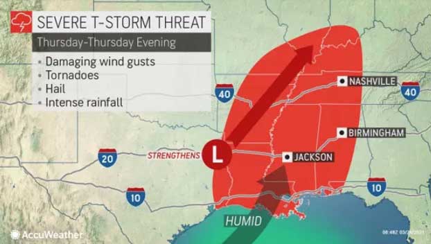
Severe weather threats, including the risk of tornadoes, will return to the area this week.
The first round of severe weather ramped up late Monday afternoon into Monday night in portions of western and central Texas, with at least one confirmed tornado and over two dozen damaging wind and hail reports, according to the National Weather Service’s Storm Prediction Center (SPC).
On Monday night, high wind gusts up to 78 mph were reported in West Texas. The severe weather damaged the roofs of multiple homes in Plains, Texas, according to SPC. In Bertram, Texas, there were reports of multiple power lines down and debris blocking roadways following a tornado-warned storm. No tornado touched down, but damaging straight-line winds led to extensive damage.
Article by Alex Sosnowski, AccuWeather senior meteorologist
More News


