Mississippi to see several rounds of storms tonight — hurricane-force winds, hail, tornadoes a possibility
Published 9:33 am Friday, April 9, 2021
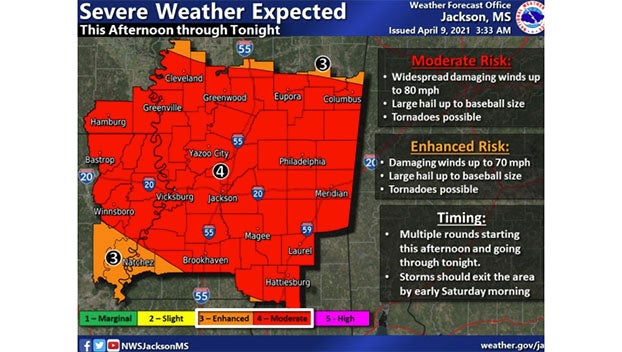
Much of Mississippi is under a moderate risk of severe weather today, including high winds, baseball size hail and the possibility of tornadoes.
At least a few tornadoes are expected Friday in parts of northeast Louisiana and Mississippi, according to the national Storm Prediction Center in Norman, Oklahoma. The threat will continue into the overnight hours, forecasters said.
Nearly 1.6 million people in a region that includes parts of Louisiana and Mississippi will be at greatest risk of severe storms on Friday, the Storm Prediction Center said in its outlook for Friday. The area includes Jackson, Hattiesburg and Vicksburg in Mississippi; and Monroe in Louisiana.
Central Mississippi has been upgraded to a rare Level 4 “Moderate” risk for significant severe weather.
The National Weather Service in Jackson says a significant severe weather event is expected to unfold across the region late Friday afternoon into early Saturday morning, as multiple rounds of severe storms are expected to impact the area.
A significant severe weather event is expected to unfold across the region late this afternoon through tonight, as multiple rounds of severe storms are expected to impact the area. Damaging winds up to 80 mph, baseball size hail, and a few tornadoes are all possible. pic.twitter.com/fdra50MXNQ
— NWS Jackson MS (@NWSJacksonMS) April 9, 2021
Although all types of severe weather will be possible, hurricane-force winds (up to 80 mph) and baseball size hail will be the main concern as storms move across the area. Tornadoes embedded in the severe line of storms will also be possible.
Several rounds of severe storms are expected starting at 4 p.m. Friday ending by Saturday at 6 a.m. The first round of storms will likely be in the evening, with the possibility of severe winds, large hail and a few tornadoes. A second line of storms is expected after midnight with a high possibility of widespread hurricane-force wind gusts. This second wave could cause damage across a wide area.
Because the storms will occur overnight, residents need to have access to weather warnings and be able to seek shelter quickly.
Chance of rain increases to 90% for Friday night with 1-2 inches possible.
Saturday is expected to see some showers or thunderstorms across the morning, decreasing from 1-4 p.m. then becoming mostly sunny with a high near 80. Chance of rain is 50%.
Mostly clear to sunny skies are expected Saturday night through Monday, with calm winds, highs in the upper 70s and lows in the low- to mid-50s.