Severe weather update: Strong storms accompanied by tornadoes and hail likely to develop after 2 p.m., could last into early morning hours
Published 11:34 am Tuesday, November 29, 2022
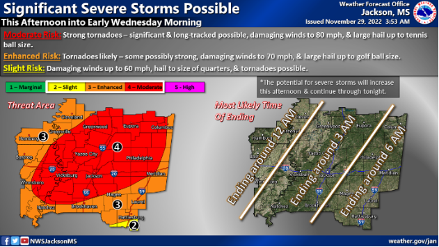
Severe weather is forecast to hit much of Mississippi Tuesday afternoon and could last into eary Wednesday morning according to the National Weather Service in Jackson.
The forecast calls for rain, strong winds and potential for tornadoes.
Severe weather is possible throughout the state. Much of Mississippi will see a risk of tornadoes, strong winds and possible golf-ball-sized hail.
Northern and western sections of the state will see the greatest threat of long-track tornadoes, tennis-ball-sized hail and winds of up to 80 mph.
The worst of the severe weather threat should start to develop around 2 p.m.
NWS Jackson forecasts the storms to hit Southwest Mississippi from this afternoon until 3 a.m. Wednesday morning and asks residents to stay weather aware.
Flash flooding is also a concern for localized heavy rainfall inundating low-lying areas, urban areas and creeks, bayous or rivers.
There is a 100 percent chance of severe thunderstorms this evening.


