Snow still possible in parts of Mississippi; dangerous cold on its way
Published 8:36 am Sunday, December 18, 2022
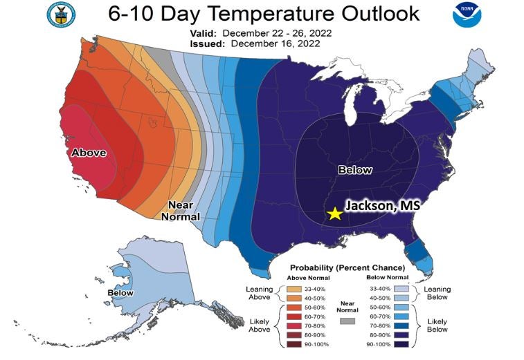
Although it’s already chilly across the state today, we’re still expecting extremely dangerous cold temps for parts of the state later this week.
In northern Mississippi, highs remain in the 40s with lows in the upper 20s to 30s the next few days. A front Thursday will bring a cold rain during the day with the possibility of snow showers as temperatures plummet to a low just below 10 degrees. Fridays high in Oxford, Tupelo, Batesville and other northern communities could top out at only 18 on Friday. People should plan now to stay below freezing until Christmas Day.
In central Mississippi, today will be sunny and cool with highs near 50. There could be some heavy rain at times on Monday, but temps in the 40s will keep any severe storms away.
Another system approaches Thursday with the chance of snow showers stretching down from the north Thursday night. Lows will drop to between 10 and 15 degrees. Highs Friday will be in the 20s with no rise about freezing until Sunday.
The extreme cold will go all the way to the Gulf of Mexico. After a nice day today, the next couple of south Mississippi days will be rainy and cold. Thursday will warm into the upper 50s to lower 60s but drop into the 20s, even along the beaches.
Remember, temperatures don’t include the potential for some strong winds at various times. Prepare now for extreme windchill the end of the week and Christmas weekend.