Mississippi Skies: Washout across the state today
Published 6:25 am Friday, December 30, 2022
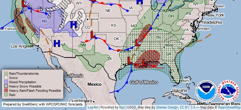
Today is a great day to catch up on some work or sleep, depending on personal obligations. Although most of the state only has a slight – but not zero – chance of severe storms, torrential rain and even flash flooding is possible. The southeastern portion of the state, especially from Hattiesburg to the Gulf Coast, has the highest chance of having a severe storm or even a weak tornado. Rain chances are high most of the day, but some areas will dry out somewhat tonight. The good news is that the rain will move east of Mississippi by New Year’s Eve.
We’re still watching a strong cold front moving in this direction early next week. Right now, it’s looking like Monday or Monday night could have more widespread severe weather.
North Mississippi
Patchy fog early and then rain moving into the area. Breezy with a high near 58 with a 90 percent chance of rain. Rainfall averaging up to half of an inch with higher amounts in storms. Rain chances drop to 50 percent by 9 p.m. with patchy fog and a low of 52.
Central Mississippi
A 90 percent chance of rain and possibly a thunderstorm with a high near 66. Mostly cloudy tonight with rain chances falling to 20 percent in the late evening. Up to an inch of rain is possible with higher amounts in thunderstorms.
South Mississippi
A 100 percent chance of rain today with a high near 70. Tonight, a 40 percent chance of showers before midnight. Up to two inches of rain is possible except for higher amounts in thunderstorms. There is a slight chance one or two of the storms could be severe.
Gulf Coast
There is a 100 percent chance of rain and thunderstorms throughout the day with a high near 70. Rain and storms continue overnight with a low of 61. The area could receive two inches of rain or more, especially with thunderstorms. Some of the storms could be severe.