Mississippi Skies: Front bringing severe weather threat Friday
Published 11:26 pm Thursday, March 7, 2024
Friday is shaping up to be a stormy day across the Magnolia State. We’ve been watching models and discussing severe weather chances for several days, and it’s finally time to finalize the forecast.
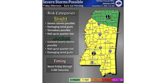
People in every part of the state can expect heavy rainfall and a thunderstorm. Then, most of the state is under a Level 2 risk for severe weather from noon Friday until 3 a.m. Saturday.
In the Level 2 zone, severe storms with winds up to 60 miles per hour are possible, along with tornadoes, hail, and flooding rainfall.
Once the front moves through, we’re expecting a fantastic remainder of the weekend, even though we lose an hour overnight Saturday.
North Mississippi
Showers throughout the day with thunderstorms in the afternoon. High of 66. Friday night, showers and thunderstorms. Low of 53.
Central Mississippi
Showers and thunderstorms becoming more numerous throughout the day. Some of the storms could be strong to severe. High of 67. More showers and storms overnight. Low of 57.
South Mississippi
A chance of showers and storms in the morning, then showers and storms likely in the afternoon. Storms could be severe. High of 71. More showers and storms overnight with a severe storm possible. Low of 59.
Gulf Coast
A shower or two in the morning, then showers and thunderstorms becoming more likely later in the day. A storm or two could be severe. High of 74. Friday night, more showers and storms. Low of 65.