Mississippi Skies Bulletin: Severe weather risk increased, expanded; risk now includes tornadoes
Published 6:36 pm Thursday, March 14, 2024
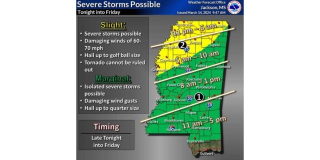
The Storm Prediction Center has made several changes in our severe weather risk.
First, the timing has changed with severe storms and tornados now possible in parts of Mississippi by Thursday night. The upgraded risk is now a Level 2 for northwestern Mississippi and includes the Mississippi suburbs of Memphis, Oxford, Batesville, Cleveland, Clarksdale, Grenada, Greenville, Corinth, and Greenwood. Tupelo is right on the line of the Level 2 and Level 1 risk.
This region can expect isolated to scattered severe storms as early as 11 p.m. tonight. The main risks are severe storms, damaging winds up to 70 miles per hour, large hail, and a tornado or two.
The rest of Mississippi – with the exception of the three counties along the Gulf Coast – is now under a Level 1 risk, beginning as early as 5 a.m. in northern Mississippi, 8 a.m. in central Mississippi, and 11 a.m. in southern Mississippi.
The main risks in the Level 1 are isolated severe storms, large hail, and damaging winds.
The severe threat should end by 5 p.m. for the southern counties, but rain is expected to occur off and on all weekend. We’ll have more details in the Mississippi Skies report for Friday.