Mississippi Skies: Tornado confirmed in Mississippi. Will there be more severe weather this weekend?
Published 11:22 pm Friday, March 15, 2024
Friday’s storm system developed at least one confirmed tornado in Mississippi.
According to the National Weather Service in Memphis, an EF1 tornado was confirmed with damage in Downtown New Albany. Winds were up to 95 miles per hour and the tornado was on the ground just less than a mile.
“The tornado developed near Reed`s Market in New Albany along West Bankhead St, causing intermittent tree damage as it moved across The Park Along the River,” the report from NWS Memphis reads. “This tornado caused damage to the backside of the Police Department on King St, resulting in minor uplift of the roof. A more consistent damage path was observed east of King St as the tornado moved along East Main St, damaging numerous trees and structures. Numerous structures suffered roof damage, with the most significant affecting the County Clerk’s office. The tornado caused additional minor roof and tree damage along Main St near Central Ave and Glade St, lifting before reaching Wilbanks St.”
We’ll have some great weather in the north Saturday with clouds hanging around in central and southern Mississippi. For anyone with work or plans in the morning, there could be some dangerous driving with widespread dense fog, especially in central and southern Mississippi.
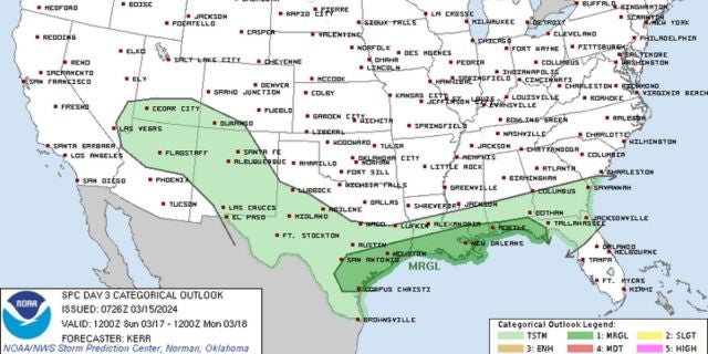
According to the Storm Prediction Center, there could be an isolated strong to severe storm along the coast and in extreme southern Mississippi.
After some more rain and storms Sunday, we’re still expecting a big drop in temperatures Monday. Highs will be in the 50s in northern and central Mississippi Monday with temperatures in the upper-20s to around 30. Southern Mississippi will be around 60 Monday, but still have freezing temperatures Monday night. The coast will be cooler but remain above freezing temperatures.
North Mississippi
Mostly sunny with a high of 70. Becoming mostly cloudy with a low of 50.
Central Mississippi
Dense fog early. Mostly cloudy with a high of 72. Overnight, mostly cloudy with a chance for a shower. Low of 54.
South Mississippi
Dense fog early. Mostly cloudy with a high of 75. Mostly cloudy overnight with a few showers. Low of 57.
Gulf Coast
Dense fog early. Partly sunny with a slight chance of showers or thunderstorms in the afternoon. High of 79. Mostly cloudy with showers and thunderstorms overnight. Low of 65.