Mississippi Skies: Severe weather threat expands for approaching system
Published 11:20 pm Saturday, March 23, 2024
We’re still on track for the possibility of some rough weather Monday night and Tuesday and we’ve seen a chance in the Storm Prediction Center’s forecast.
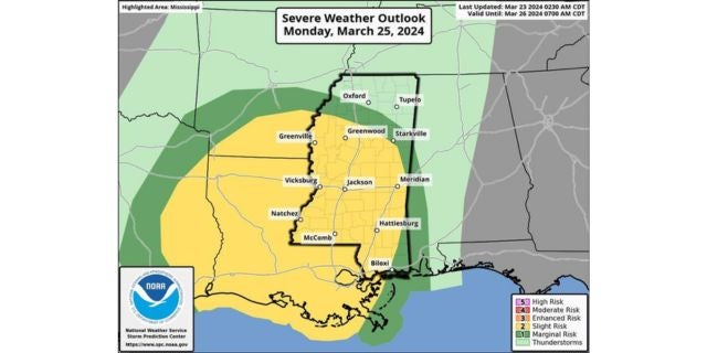
The latest SPC outlook shows the Level 2 now covers most of Mississippi from Greenwood and Starkville all the way down to Biloxi. A thin Level 1 risk circles the Level 2. Even though most of the state could have some severe weather, northern Mississippi is not included in the severe risk at this time.
From the National Weather Service:
“Severe storms are possible Monday night through early Tuesday morning. Potent weather system will support severe storm potential, including tornadoes. Make your severe weather preparations ahead of this potential overnight severe weather event.”
North Mississippi
Partly sunny and breezy with a high of 65. Sunday night, mostly cloudy with a low of 50. Breezy with wind gusts up to 30 miles per hour.
Central Mississippi
Partly sunny with a high of 68. Becoming cloudy overnight with a low of 54 and wind gusts up to 25 miles per hour.
South Mississippi
Partly sunny with a high of 70. Mostly cloudy overnight with a low of 54. Wind gusts up to 30 miles per hour.
Gulf Coast
Becoming cloudy with a high of 72. Mostly cloudy and breezy Sunday night with a low of 60.