Mississippi Skies Bulletin: ‘Hatched’ tornado risk zone issued for parts of Mississippi
Published 5:24 pm Sunday, March 24, 2024
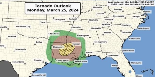
Our severe weather potential has been upgraded again by the Storm Prediction Center and this update includes a “hatched” area for tornado potential.
According to the SPC, the hatched area signifies having a 10 percent probability of an EF2 to EF5 tornado within 25 miles of any given point inside the zone.
The map shows the exact locations for each of the risk areas, but the highest risk for this round of storms includes Jackson, Vicksburg, Natchez, Clinton, Pearl, Brandon, McComb, Brookhaven, Mendenhall, Port Gibson, Tylertown, Prentiss, and other nearby communities.
For people traveling, this risk area includes Monroe and Alexandria, La.
The five percent risk zone includes most of the Mississippi Delta, Philadelphia, Meridian, Forest, Newton, Laurel, Collins, Raleigh, Columbia, Hattiesburg, Wiggins, and Picayune. A two percent risk includes most of the rest of the state, including Batesville, Oxford, Gulfport, Lucedale, Starkville, Columbus, and Pascagoula.
The new Severe Weather Outlook places the entire state under at least some risk for severe storms. A Level 3 Enhances now covers about the same area of the 10 percent tornado hatched zone. Besides the tornado risk, winds up to 70 miles per hour and hail are possible. A Level 2 includes much of the five percent hatch and a Level 1 covers the two percent hatch. Severe weather is possible in all areas without as much confidence as the enhanced zone.
Storms are expected from about 4 p.m. until 7 p.m. in our Mississippi River communities and western Mississippi, 7 p.m. until 10 p.m. in central Mississippi, and 10 p.m. until 3 a.m. for eastern Mississippi.