Mississippi Skies: Severe weather threat upgraded with at least some threat for every part of Mississippi
Published 10:02 pm Monday, April 1, 2024
The strong cold front we’ve been watching for several days is finally approaching and models are certainly expecting it to pack quite a punch before temperatures drop.
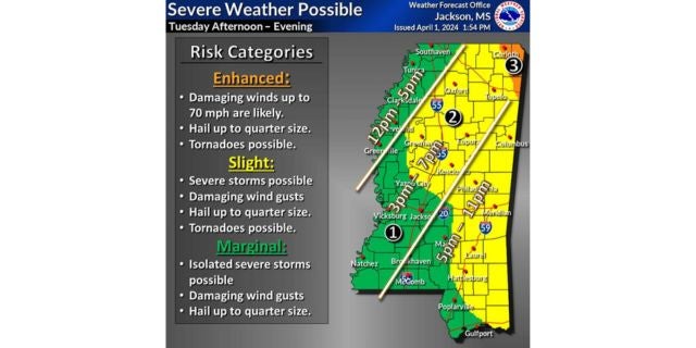
The Storm Prediction Center now has a Level 3 risk for northeastern Mississippi, including Corinth. Wind and hail are the main threats, but a tornado is possible.
A Level 2 now includes most of central Mississippi and eastern Mississippi. Cities inside the risk zone include Oxford, Batesville, Tupelo, Grenada, Greenwood, Starkville, Columbus, Philadelphia, Meridian, Laurel, Hattiesburg, Wiggins, and Pascagoula. This area includes the same risks, but without as much confidence. A Level 1 includes the rest of the state.
Storms are expected to begin by noon in the Delta, 3 p.m. in our southern Mississippi River counties and central Mississippi, and 5 p.m. in the Pine Belt and eastern Mississippi.
North Mississippi
Showers and storms likely. High of 77. Tuesday night, mostly cloudy with a few showers or storms. Low of 44. Storms could be severe.
Central Mississippi
Rain and thunderstorms with a high of 81. Storms could be severe. More rain overnight with a low of 47.
South Mississippi
Cloudy, then becoming sunny with a slight chance of a shower or storms in the afternoon. High of 85. A storm or two could be severe. Mostly cloudy overnight with a shower or storm possible. Low of 51.
Gulf Coast
Mostly cloudy with a high of 81. A slight chance of a shower or strong storm in the evening. Becoming partly cloudy overnight. Low of 56.


