Mississippi Skies: Four days of storm potential begin Sunday; severe weather possible in several waves
Published 10:17 pm Saturday, April 6, 2024
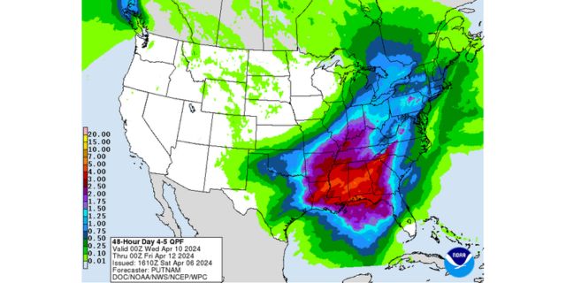
- Projected rainfall totals for the upcoming week
Several chances of thunderstorms will bring several chances of severe weather between Sunday and Wednesday. Although the main threat is shaping up to arrive Wednesday, various parts of the state will have various risks at various times.
According to the National Weather Service, a Level 1 risk covers the northwestern and western Mississippi Sunday and Monday from 3 p.m. until 9 p.m. each day. Communities included in the risk area are Natchez, Vicksburg, Yazoo City, Greenwood, Greenville, and Cleveland.
We’re not expecting a washout, but isolated storms. Storms that do develop could become severe with damaging winds and hail.
For Wednesday, just about the entire state is already under a Level 2 risk. We’re still a few days out so details can change, but all modes of severe weather seem possible at this time, including tornadoes.
Models are showing Monday to be mostly cloudy across most of the Magnolia State. Some of us could be lucky to have enough clearing to see the eclipse, but many of us will be too cloudy.
North Mississippi
Mostly sunny with a slight chance of a shower or thunderstorm in the late afternoon. Becoming mostly cloudy overnight with showers and thunderstorms likely. Low of 59.
Central Mississippi
Partly sunny and breezy with wind gusts up to 25 miles per hour. High of 79. Mostly cloudy overnight with a slight chance of a shower or thunderstorm. Low of 61.
South Mississippi
Fog early. Partly sunny and breezy with wind gusts up to 20 miles per hour. High of 80. Becoming mostly cloudy with a low of 60.
Gulf Coast
Partly sunny with a high of 77. Mostly cloudy overnight with a low of 64.


