Mississippi Skies: Stormy weather continues with increasing severe threat
Published 9:10 pm Sunday, April 7, 2024
The much-anticipated eclipse may not be seen across Mississippi. Monday brings another chance for some soggy weather and strong storms in the Magnolia State.
Although the chances are low, the area of possible severe storms for Monday has expanded. A Level 1 risk covers most of the state now. The only regions not included are the Pine Belt and Gulf Coast in Monday’s risk.
The timing is from 3 p.m. until 9 p.m. and includes the risk of severe storms, hail, and damaging winds. A brief tornado can’t be ruled out completely.
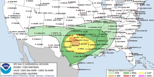
Don’t look for our severe chances to end anytime soon. Tuesday’s risk includes the western side of Mississippi with a Level 2 for our Mississippi River region and includes the cities of Natchez and Vicksburg. Tornadoes will be possible, especially in the Level 2 risk zone.
Wednesday’s risk is already a Level 2 for just about the entire state. Tornadoes will be possible statewide.
North Mississippi
Mostly cloudy with some showers and thunderstorms in the afternoon. High of 75. Showers and thunderstorms Monday night with a low of 58.
Central Mississippi
Cloudy with a few showers and thunderstorms. High of 77. Showers and thunderstorms likely overnight with a low of 59.
South Mississippi
A chance of showers and storms in the morning through midday, then showers likely with a few storms possible in the later afternoon. Cloudy with a high of 77 and wind gusts up to 20 miles per hour. Showers and storms likely overnight with a low of 62.
Gulf Coast
Mostly cloudy with a slight chance of showers and thunderstorms in the afternoon. High of 77. Mostly cloudy overnight with a low of 66.


