Mississippi Skies Bulletin: Significant severe weather, strong tornadoes possible
Published 4:42 pm Tuesday, April 9, 2024
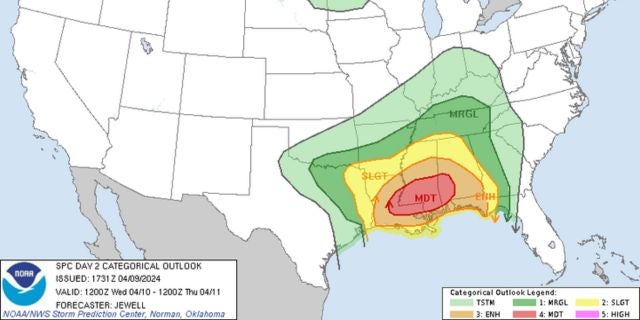
The system we’ve been expecting to arrive Wednesday is still on its way and the Storm Prediction Center is taking it seriously. Much of the southern half of the state is under a rare Level 4 risk of severe weather.
Storms will begin as early as 8 a.m. along the Mississippi River, spreading eastward throughout the day.
The Level 4 risk includes Natchez, Brookhaven, McComb, Prentiss, Magee, Jackson, Brandon, Madison, Forest, Meridian, Laurel, Collins, Columbia, Hattiesburg, Picayune, Poplarville, Wiggins, and Lucedale.
In this risk zone, damaging winds up to 80 miles per hour, large hail, severe storms, and tornadoes are likely. A few of the tornadoes could be strong.
A Level 3 risk includes the area from the Level 4 zone to the U. S. Hwy. 82 corridor, along with the Gulf Coast. Severe storms and tornadoes are likely with winds up to 70 miles per hour.
The Level 2 covers the remaining Mississippi regions not already included. Risks are the same without as much confidence.


