Mississippi Skies: Severe weather outbreak becoming likely for Wednesday
Published 11:30 pm Tuesday, April 9, 2024
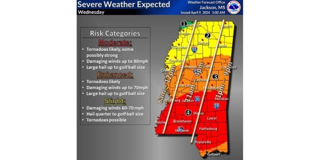
The system we’ve been expecting to arrive Wednesday is still on its way and the Storm Prediction Center is paying very close attention. Much of the southern half of the state is under a rare Level 4 risk for severe weather.
Storms will begin as early as 8 a.m. along the Mississippi River, spreading eastward throughout the day.
The Level 4 risk includes Natchez, Brookhaven, McComb, Prentiss, Magee, Jackson, Brandon, Madison, Forest, Meridian, Laurel, Collins, Columbia, Hattiesburg, Picayune, Poplarville, Wiggins, and Lucedale.
In this risk zone, damaging winds up to 80 miles per hour, large hail, severe storms, and tornadoes are likely. A few of the tornadoes could be strong.
A Level 3 risk includes the area from the Level 4 zone to the U. S. Hwy. 82 corridor, along with the Gulf Coast. Severe storms and tornadoes are likely with winds up to 70 miles per hour.
The Level 2 covers the remaining Mississippi regions not already included. Risks are the same without as much confidence.
North Mississippi
A chance of showers and storms, then showers likely afternoon with a few storms possible. High of 70. Showers continue with a few storms possible. Low of 52. A storm or two could be severe.
Central Mississippi
Showers likely with thunderstorms possible. Some of the storms could be severe. High of 72. Showers and storms continue overnight with some severe storms possible. Low of 54.
South Mississippi
Showers and storms likely with widespread severe weather possible. High of 74. Showers and storms continue overnight with a low of 56. Severe storms possible overnight.
Gulf Coast
Showers and storms possible. Severe weather possible. High of 76. More showers and storms overnight with a low of 59.


