Mississippi Skies: Severe weather threat area expands; dense fog possible Monday morning
Published 10:45 pm Sunday, April 14, 2024
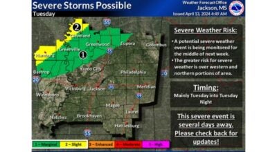
- Tuesday's severe weather outlook
Monday morning will bring a risk of dense fog for parts of the Magnolia State with some areas being quite dangerous during the morning commute.
Parts of the Pine Belt have a Level 1 risk for dense fog while southeastern Mississippi, including Hattiesburg, is under a Level 2.
In the Level 2, visibility is expected to drop to less than a quarter of a mile. In the Level 1, patchy dense fog could have visibility to between a quarter and a half a mile.
As far as the severe threat goes, parts of the Delta are under a Level 2 risk while most of the northeastern quadrant of the state is under a Level 1.
Storms are expected Tuesday afternoon until Tuesday night. The main risks are severe storms, damaging winds, and hail, although a tornado can’t be ruled out. The risk is greater in the Level 2.
The good thing about this storm system is that storms will be isolated to scattered as not all areas will receive severe weather. The southern region of the state may not even have any rain at alll
North Mississippi
Mostly sunny with a high of 81. Becoming cloudy Monday night with a low of 62.
Central Mississippi
Sunny with a high of 82. Increasing cloudy overnight with a low of 61.
South Mississippi
Dense fog possible. Sunny with a high of 83. Becoming mostly cloudy overnight with a low of 61.
Gulf Coast
Widespread dense fog. Mostly cloudy early, then becoming sunny. High of 80. Monday night, cloudy with a low of 63.