Mississippi Skies: Chance for severe weather remains for some
Published 10:55 pm Monday, April 15, 2024
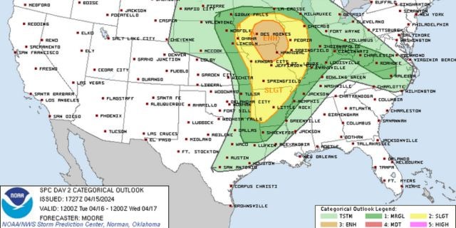
The Storm Prediction Center is keeping a severe threat for parts of Mississippi Tuesday evening and have added a chance Wednesday.
We’re still not expecting widespread severe weather, nor even a solid chance of rain with this system as most of the storms will remain north of Mississippi.
Tuesday’s Level 1 risk is from 4 p.m. until 2 a.m. for the northwestern corner of the state, including Clarksdale, Cleveland, and the Memphis suburbs inside Mississippi. Batesville is right at the border of the risk area. For anyone traveling into Tennessee or Arkansas, the risk increases.
Wednesday, a Level 1 risk includes the Memphis suburbs, Holly Springs, and Corinth. Oxford and Tupelo are not included in the risk zone but are right south of the border.
The main risks on both days are isolated severe storms, hail, wind, and a tornado or two.
Otherwise, we’ll have plenty of gusty winds across the state. Some of us will have some clouds Tuesday morning, then it will become partly sunny to partly cloudy. More clouds will move in throughout the state Tuesday night.
North Mississippi
Partly sunny with a high of 81. Windy with gusts up to 25 miles per hour. Showers and thunderstorms overnight. A storm or two could be strong to severe. Low of 67.
Central Mississippi
Cloudy, then becoming sunny. Windy with a high of 82. Tuesday night, becoming cloudy with a slight chance of a shower. Low of 65.
South Mississippi
Cloudy, then becoming sunny. Windy with a high of 83. Mostly cloudy Tuesday night with a low of 65.
Gulf Coast
Fog early. Partly sunny with a high of 79. Mostly cloudy overnight with a low of 67.