Mississippi Skies: First severe weather threat coming Thursday
Published 10:29 pm Wednesday, March 13, 2024
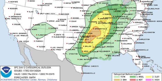
- Thursday severe weather outlook
The first round of several chances of rain and storms arrives in Mississippi Thursday. With this first round, some of us could have a severe storm or two Thursday afternoon or evening. Then, severe weather is possible across most of the state Friday morning.
For Thursday’s risk, the northern two-thirds of the state are under a Level 1 risk from the Storm Prediction Center. Large hail, strong winds, and isolated severe storms are possible.
The same risks cover the state Friday.
Besides the severe weather chances, most of the state also has a risk for flash flooding. We’re expecting some places in the state to have upwards of five or six inches of rain by the time we dry out in a few days.
North Mississippi
Partly sunny with a shower or thunderstorm possible in the afternoon and evening. High of 78. Showers likely overnight with a few thunderstorms possible. Low of 61. A storm or two could be severe in the afternoon and evening.
Central Mississippi
Partly sunny with a slight chance of a shower or thunderstorm. High of 79. Wind gusts up to 20 miles per hour. A storm or two could be severe in the afternoon and evening. More showers and storms overnight. Low of 62.
South Mississippi
Partly sunny with a slight chance of a shower in the afternoon. High of 79. Wind gusts up to 20 miles per hour. Mostly cloudy Thursday night with a slight chance of a shower. Low of 64.
Gulf Coast
Fog early. Mostly cloudy with a slight chance of a shower or thunderstorm in the afternoon. High of 79. Thursday night, more fog with a chance of an isolated shower. Low of 67.