Mississippi Skies: Severe weather becoming likely in parts of the Magnolia State Monday
Published 9:23 pm Sunday, March 24, 2024
 We’ll have a calm morning starting out Monday, but just about the entire state could have a few thunderstorms by Monday night.
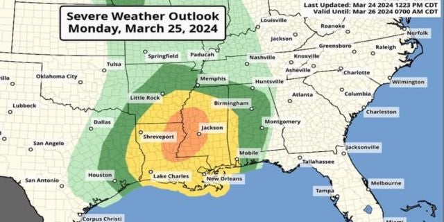
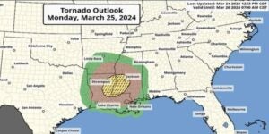
Our severe weather potential has been upgraded by the Storm Prediction Center and this update includes a “hatched” area for tornado potential.
Even without severe storms, we’ll all deal with strong wind gusts and most of us will have torrential rainfall.
According to the SPC, the hatched area signifies having a 10 percent probability of an EF2 to EF5 tornado within 25 miles of any given point inside the zone.
The map shows the exact locations for each of the risk areas, but the highest risk for this round of storms includes Jackson, Vicksburg, Natchez, Clinton, Pearl, Brandon, McComb, Brookhaven, Mendenhall, Port Gibson, Tylertown, Prentiss, and other nearby communities.
For people traveling, this risk area includes Monroe and Alexandria, La.
The five percent risk zone includes most of the Mississippi Delta, Philadelphia, Meridian, Forest, Newton, Laurel, Collins, Raleigh, Columbia, Hattiesburg, Wiggins, and Picayune. A two percent risk includes most of the rest of the state, including Batesville, Oxford, Gulfport, Lucedale, Starkville, Columbus, and Pascagoula.
The new Severe Weather Outlook places the entire state under at least some risk for severe storms. A Level 3 Enhances now covers about the same area of the 10 percent tornado hatched zone. Besides the tornado risk, winds up to 70 miles per hour and hail are possible. A Level 2 includes much of the five percent hatch and a Level 1 covers the two percent hatch. Severe weather is possible in all areas without as much confidence as the enhanced zone.
Storms are expected from about 4 p.m. until 7 p.m. in our Mississippi River communities and western Mississippi, 7 p.m. until 10 p.m. in central Mississippi, and 10 p.m. until 3 a.m. for eastern Mississippi.
North Mississippi
Cloudy with a few showers and storms possible in the late afternoon and evening. Cloudy with a high of 64 and wind gusts up to 45 miles per hour. Showers and thunderstorms overnight. Low of 53. A storm or two could be strong to severe.
Central Mississippi
Cloudy with a shower or two possible. Wind gusts up to 45 miles per hour. High of 69. Showers are likely on Monday evening and Monday night with a few storms possible. A couple of storms could be severe. Low of 56.
South Mississippi
A chance of showers throughout the day with thunderstorms possible in the late afternoon. Wind gusts up to 45 miles per hour. High of 73. More showers and storms likely into the evening and overnight. Low of 58. A few storms could be severe, especially in western communities.
Gulf Coast
Mostly cloudy with a chance of showers. Storms possible in the late afternoon into evening. Wind gusts up to 45 miles per hour. High of 76. Overnight, showers and storms are likely. Wind gusts up to 30 miles per hour. Low of 62. A storm or two could be strong to severe.