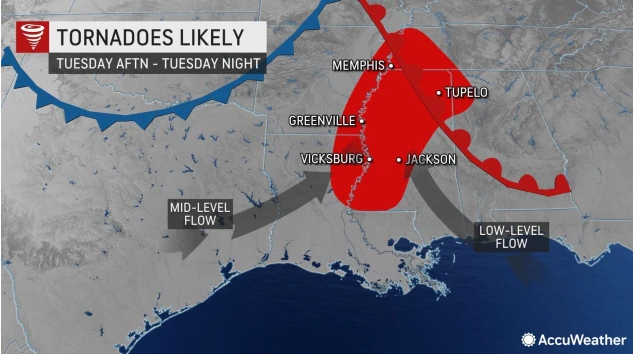
Forecasters: Tornadoes likely in parts of Southeast US — including Mississippi — on Tuesday
Published 12:00 pm Monday, November 28, 2022
By Alex Sosnowski, AccuWeather senior meteorologist
As a potent, multifaceted storm rolls out from the Rockies, severe weather ranging from high winds to tornadoes will be possible from the northwestern Gulf coast to the Mississippi Valley, AccuWeather meteorologists warn.
Approximately 30 million people in the south-central United States will be at risk for severe thunderstorms on Tuesday alone.
“We are fairly confident that there will be multiple tornadoes on the ground from late Tuesday to early Tuesday night,” AccuWeather Chief On-Air Meteorologist Bernie Rayno said. “People should take this threat seriously.”
The storm will interact with warmth and moisture from the Gulf of Mexico pushed along by stiff winds. Heavy, gusty and perhaps violent thunderstorms will erupt later in the day Tuesday and Tuesday night as energy from the jet stream moves in miles above the ground.
The first storms are likely to fire from portions of northeastern Texas, northwestern Louisiana and central and eastern Arkansas from mid-to-late afternoon on Tuesday. As a push of colder air continues to move along, the storms will shift eastward into western and central portions of Mississippi and expand northward into southeastern Missouri, southern Illinois and the western parts of Kentucky and Tennessee during Tuesday evening.
The most widespread threat from the storms on Tuesday will likely be due to damaging wind gusts, which will be capable of downing trees and power lines and causing damage to structures. Gusts from the storms will frequently reach 60-70 mph with an AccuWeather Local StormMax™ wind gust to 85 mph possible.
However, given the extreme amount of wind shear expected in the atmosphere, a number of thunderstorms may become intense enough to produce tornadoes. Wind shear is the change in winds from the ground to several thousand feet up in the atmosphere and can cause thunderstorms to rotate. When a thunderstorm rotates, the risk of a tornado increases substantially.
“Across portions of Louisiana, Arkansas and Mississippi, conditions should allow for storms to easily begin rotating, leading to a heightened tornado threat. With such an environment in place, a couple of strong, long-tracked tornadoes also cannot be ruled out,” AccuWeather Meteorologist Andrew Johnson-Levine said.
Tornadoes are far from unheard of this time of the year. On Saturday, a tornado was confirmed in St. Charles Parish, Louisiana. The storm knocked down trees, caused power outages to 10,000 utility customers and damaged buildings in Paradis, Louisiana, Saturday afternoon. There were no reports of injuries.
Since the tornado risk will extend into the nighttime hours on Tuesday, it will pose an added danger of not being able to see the storm in advance. Not all of the storms may produce frequent lightning that would illuminate the storm, and there is the added risk that heavy rain may conceal the tornado.
Downpours will be heavy enough to not only reduce the visibility for motorists, but may also lead to excess water on the roads and urban flooding.
Major metro areas in the path of the storms from late Tuesday to Tuesday night include Houston; Shreveport, Louisiana; Little Rock, Arkansas, and Memphis, Tennessee.
The risk of severe thunderstorms will continue to some extent on Wednesday farther to the east.
“On Wednesday, atmosphere conditions will begin to trend less favorable for severe weather, but that may not be enough to prevent isolated damaging storms from occurring,” AccuWeather Storm Warning Meteorologist Joe Bauer stated. “The greatest risk of severe thunderstorms may be near the Interstate-10 corridor of the central Gulf coast, but some strong storms may extend as far north as middle Tennessee as well.”
Fast movement of the storm system and a trailing cold front will keep the severe weather threat limited to a period of six to eight hours in most cases. That fast motion may allow strong to locally severe storms to push eastward later Wednesday to Wednesday evening in the central portions of Georgia and the Carolinas.
Major metro areas that could experience a period of thunderstorms capable of producing flash flooding and damaging wind gusts on Wednesday include New Orleans, Atlanta, Nashville and Birmingham, Alabama.
As the storms swing through the major hubs from Tuesday afternoon to Wednesday evening, airline delays and ground stops are likely.