Mississippi Skies: Rain, chance of severe weather today; wintry weather next week?
Published 12:32 am Sunday, January 29, 2023
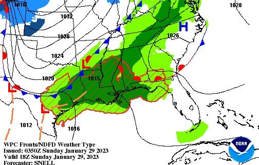
We’re keeping an eye on two systems over the next couple of days across the Magnolia State. First up, parts of southern Mississippi could have some severe storms and even a tornado or two today. On Tuesday, our friends to the north are being advised of the potential for freezing rain. Right now, the risk ends at the state line, but any change could bring that risk into northern Mississippi. We’ll update on that potential with our next Mississippi Skies post.
The largest risk for severe weather today is a Level 1, but southern Mississippi from a Natchez to Brookhaven to Hattiesburg line towards the Gulf Coast has a threat for damaging winds, hail, and an isolated tornado, mainly from 1 until 9 p.m.
In the meantime, just about everyone in the state will get some rain today. Some people will experience some heavy rain and thunderstorms. It doesn’t clear up much over the next week, so keep those umbrellas handy.
North Mississippi
Showers and possibly a thunderstorm with a high near 60 today. Wind gusts up to 25 miles per hour. Scattered showers until midnight tonight, then cloudy with a low of 43.
Central Mississippi
Showers and thunderstorms with a high near 62 and wind gusts up to 30 miles per hour. Tonight, showers and storms continue with a low of 53. Rainfall up to two inches possible.
South Mississippi
Showers and thunderstorms with some isolated to scattered severe storms possible. High of 66 and windy. Storms continue tonight with a low of 59. Rainfall up to two inches possible.
Gulf Coast
Showers and thunderstorms with a high near 70. Tonight, showers and scattered storms continue with a low of 62. Rainfall up to two inches possible.